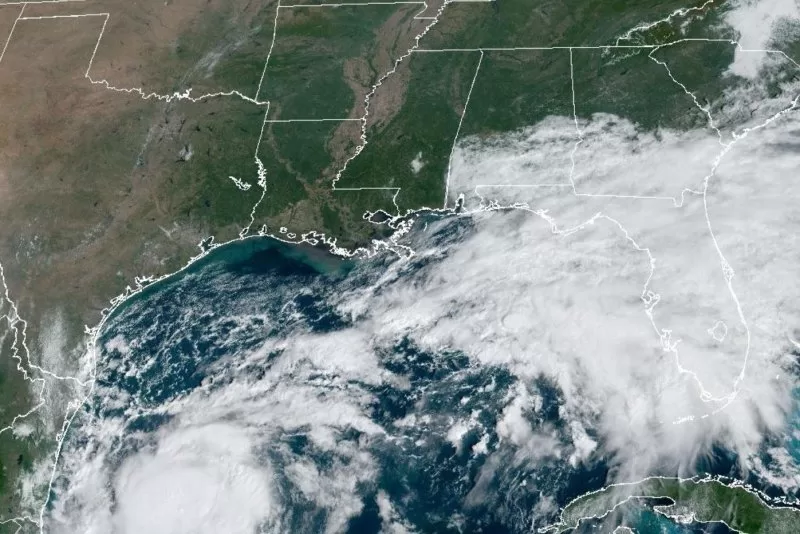
1 of 3 | Tropical Storm Milton formed in the Gulf of Mexico and is forecast to impact Florida as a hurricane. Satellite image courtesy National Oceanic and Atmospheric Administration
Oct. 6 (UPI) — Hurricane Milton is inching toward Florida’s west coast where residents face “life-threatening impacts,” according to the National Hurricane Center, a state that is still reeling from the impacts of Hurricane Helene, a Cat. 4 storm that battered the state 10 days ago.
Residents are making major preparations for a storm that will affect much more of their state and many more residents than Hurricane Helene did when it came ashore September 26th near the sparsely populated area of Big Bend then quickly turned north, sparing many of the state’s largest population centers.
Milton is expected to make landfall as a major hurricane by midweek, forecasters predict. A detailed storm tracker shows where the storm is predicted to arrive, on what day, and at what time, CNN shows.
Forecasters predict Milton will make landfall shortly after 11 a.m. Wednesday at Sarasota, cut directly across the state diagonally, and leave Florida just south of Cape Canaveral, traveling out to the Atlantic on the East side of the state as a Cat. 1 storm.
Miami, Orlando and Tampa are each forecast to receive as mush as eight inches of rain through Thursday, the equivalent of an entire month’s worth of rain for Miami, two months’ worth of rain for Orlando and three months’ worth for Tampa. Some places in Florida’s interior could see as much as 10 inches of rain as the storm barrels through
Two hurricanes already were churning with no threat to land in the Atlantic Ocean: Kirk, a Category 3 storm, and Leslie, which became a hurricane late Friday.
Milton, the 13th named storm of the season in the Atlantic, will become a major hurricane — at least a Category 3 — late Monday, NHC said.
The Florida Division of Emergency Management is preparing for the largest evacuation since 2017, Director Kevin Guthrie said at a news conference with DeSantis on Sunday.
Schools in Hillsborough County, Pinellas County and Pasco County will be closed and other activities have been canceled from Monday through Wednesday as a precaution. Hillsborough County Schools could be converted into evacuation shelters.
Other local areas are also making provisions for Milton while still trying to clean up from Hurricane Helene, which killed hundreds of people, caused widespread damage and power outages across the entire southeastern United States.
“I urge Floridians to finalize your storm preparations now, enact your plan. I highly encourage you to evacuate,” Guthrie said.
On the forecast track, the storm is forecast to approach Florida’s west coast by midweek and is projected to make landfall as a major hurricane.
“The NOAA Hurricane Hunter crew reported that an eyewall has formed on the last center fix, suggesting that this system is ready to intensify quickly,” NHC Forecaster Eric Blake wrote.
NHC had been tracking the disturbance in the Gulf since Friday. It became a depression Saturday morning and a tropical storm Saturday afternoon.
Most of Florida is in NHC’s forecast cone.
Florida Gov. Ron DeSantis declared a state of emergency in 51 of the state’s 67 counties, including metro areas of Tampa-St. Petersburg, Miami-Fort Lauderdale-West Palm Beach and Orlando.
DeSantis warned at a news conference Sunday that after making landfall on Florida’s west coast, Milton could move east across Central Florida.
“You’re going to have the storm going right across, potentially I-4 or certainly in the center part of the state somehow, and that is going to cause damage,” DeSantis said.
“That’s going to generate debris, it’s going to cause potential damage to infrastructure. So just be prepared for that and do what you need to do to be able to execute your plan.”
All assets deployed to North Carolina for Helene are returning to Florida.
As of 7:00 PM CDT Sunday, Hurricane Milton is located at 22.5°N 93.4°W moving at east at 7 mph with maximum sustained winds of 85 mph, the NHC said.
The storm is located about 785 miles west-southwest of Tampa, the NCH said.
Tropical storm-force winds continue to extend up to at least 60 miles from the center of the storm.
Interests on the Yucatan peninsula of Mexico, the Florida Peninsula, the Florida Keys and the northwestern Bahamas should monitor the progress of this system, according to NHC.
Swells “could cause life-threatening surf and rip current conditions” by early next week along much of the Gulf Coast, NHC said.
Significant rain also is forecast for other areas of Florida, as well.
Rainfall of 5 to 8 inches, with localized totals up to 12 inches, are expected across Florida, including the Keys, through Wednesday night.
“This rainfall brings the risk of flash, urban and areal flooding, along with widespread minor to moderate river flooding with major flooding possible,” NHC said.
A flood watch was in effect for South Florida, which was experiencing showers and thunderstorms.
Florida’s west coast has already been hit by two hurricanes this season.
Hurricane Helene hit the coast near Perry in the Big Bend Region on Sept. 26 as a Category 4 storm.
Hurricane Debby hit nearby Steinhatchee as a Category 1 storm on Aug. 5.
Kirk, in the 5:00 PM AST update Sunday by the NHC, had maximum sustained winds of 85 mph, and was about 1,050 miles west- of The Azores. Kirk was moving north-northeast at 23 mph.
There are no coastal watches or warnings in effect. Hurricane-force winds extend outward up to 115 miles from the center and tropical-storm-force winds extend outward up to 290 miles.
“Kirk will remain a large hurricane for the next day or so before transitioning to an extratropical cyclone by Monday night,” NHC said.
Swells generated by Kirk are affecting the Leeward Islands, Bermuda, the Greater Antilles, the Bahamas, the East Coast of the United States.
They are likely to cause life-threatening surf and rip current conditions.
Leslie was designated as a hurricane in the 11 p.m. Friday NHC advisory.
In the 5:00 PM AST update, Leslie had maximum sustained winds of 85 mph, and was about 1050 miles west of the Azores, and moving northwest at 23 mph.
There are no coastal watches or warnings in effect. Hurricane-force winds extend outward up to 15 miles from the center and tropical storm-force winds extend outward up to 90 miles.
NHC said weakening is forecast to begin Monday and continue through early midweek.