NHC forecasters on Tuesday said newly formed Tropical Storm Helene is forecast to grow “significantly” in the next few days as they issued a tropical storm warning for the Lower Florida Keys. Image courtesy of NOAA
Sept. 25 (UPI) — Tropical Storm Helene is expected to strengthen rapidly Tuesday night as it travels over the Gulf of Mexico, according to forecasters who say it should hit Florida late Thursday.
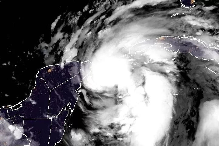
According to a 10 p.m. update from the National Hurricane Center, the tropical storm was about 100 miles east-southeast of Cozumel, Mexico, and about 140 miles south-southwest of the western tip of Cuba.
It had maximum sustained winds of 60 mph and was moving west-northwest at 10 mph.
The storm is forecast to “strengthen rapidly over the Gulf of Mexico” and grow to “a large size.”
“Helene is forecast to intensify and be near hurricane strength when it passes near the northeastern coast of the Yucatan Peninsula on Wednesday,” the NHC said.
A turn toward the northwest is expected later Tuesday night. On Wednesday and continuing until Friday, it is forecast to move in a general northward direction.
“The center of Helene will pass near the northeastern coast of the Yucatan Peninsula later tonight or early Wednesday, move across the eastern Gulf of Mexico on Wednesday and Thursday and reach the Big Bend coast of Florida late Thursday,” it said.
A hurricane watch was in effect for the Cuban province of Pinar del Rio and from Englewood to Anclote River, including Tampa Bay.
A hurricane warning has been called for the Anclote River to Mexico Beach Fla., and Cabo Catoche to Tulum, Mexico.
A tropical storm warning was in effect for Dry Tortugas, lower and middle Florida Keys west of the Channel 5 Bridge, Flamingo to Anclote River, west of Mexico Beach to the Walton-Bay County Line, Palm Beach-Martin County Line northward to the Flagler-Volusia County Line, Lake Okeechobee, Rio Lagartos to Cabo Catoche and the Cuban provinces of Artemisa, Pinar del Rio and the Isle of Youth.
A tropical storm watch has been called for the Flagler-Volusia County Line north to the Savannah River.
A tropical storm warning means that tropical storm conditions are expected somewhere within the warning area, in this case within the next 24 to 36 hours. A hurricane watch means that hurricane conditions are possible within the watch area, typically within 48 hours before the anticipated first occurrence of tropical-storm-force winds.
Meanwhile, a storm surge warning was in effect for Indian Pass south to Flamingo, Tampa Bay and Charlotte Harbor.
Helene is expected to produce 4 to 8 inches of rain over western Cuba, the Cayman Island, the northeast Yucatan Peninsula and the southeastern United States with isolated totals of 12 inches, leading forecasters to warn there is a considerable risk of flooding
“This rainfall will likely result in areas of considerable flash and urban flooding, with areas of significant river flooding.Landslides are possible in areas of steep terrain in the southern Appalachians,” the NHC said.