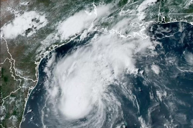
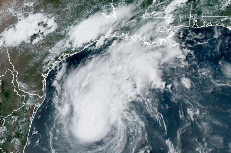
1 of 3 | Tropical Storm Beryl was moving toward the Texas coast. Image by National Oceanic and Atmospheric Administration.
July 5 (UPI) — Tropical Storm Beryl was nearing landfall in Texas after striking portions of the western coast of the Gulf of Mexico and earlier in the week the islands in the southwest Caribbean.
In the 4 p.m. CDT update Saturday, the National Hurricane Center said Beryl was about 385 miles southeast of Corpus Christi with maximum sustained winds of 60 mph. Beryl was moving west-northwest at 13 mph.
Bery is forecast to intensify as a Category 1 hurricane — at least 74 mph — by late Sunday into early Monday and near Corpus Christi around 7 a.m.
It would be the first U.S. landfall of the 2024 hurricane season, which began on June 1.
Texas residents are bracing for impact.
“We pray and we hope for nothing more of a rain event, but even a rain event may be very heavy,” Texas Lt. Gov. Dan Patrick said. “We prepare at the state for the worst-case scenario.”
Several counties along the Texas Coast have asked residents to evacuate. Texas Gov. Greg Abbott has issued severe weather disaster declarations for 40 counties.
Weather forecasters warned of “life-threatening storm surge” from North Entrance of the Padre Island National Seashore northward to San Luis Pass, including Corpus Christi Bay and Matagorda Bay. A storm surge watch has been issued along the Texas coast east of High Island to Sabine Pas.
“The combination of storm surge and tide will cause normally dry areas near the coast to be flooded by rising waters moving inland from the shoreline,” NHC said.
Storm surge will be up to 6 feet along the Texas cast.
Rainfall of 5 to 10 inches with a localized amount of 15 inches is expected across portions of the Texas Gulf Coast and eastern Texas beginning late Sunday through the middle of next week.
“Flash and urban flooding, some of which may be locally considerable, is likely across portions of the Texas Gulf Coast and eastern Texas beginning late Sunday through the middle of next week,” NHC forecaster Jack Bevin said. “River flooding is also possible.”
In the update, NHC listed a hurricane warning is effect for the Texas coast from Baffin Bay northward to Sargent.
A tropical storm warning is now in effect for the Texas coast north of Sargent to High Island.
Tropical storm winds extend outward up to 125 miles from the center.
NHC forecasters say a turn to the northwest is expected later Saturday and then north-northwestward by Sunday night. On the forecast track, the center of Beryl is expected to approach the Texas coast by late Sunday through Monday morning.
Meteorologists say that the storm is expected to re-intensify once back in the Gulf of Mexico, but it will be difficult for the once Category 5 storm to reach it former levels.
“Beryl’s structure this morning is a shadow of its former self in the Caribbean, with the low-level center partially exposed and displaced south of the best mid-level rotation and deep convection,” NHC forecaster Philippe Papin said.
Landfall is key for determining the point where heavy rain will inland, Accuweather meteorologist Alex Sosnowski said.
“At this time, the eye is forecast to move inland,” he said. “However, wobbles with the center and the possibility that the storm may try to turn to the north upon nearing the coast at the last minute could push landfall significantly farther to the north in Texas.
Since 1850, more than 50 hurricanes made landfall in Texas.
The last one was when Nicholas, a Category 1 hurricane, came ashore in Matagorda County in 2021.
In 2008, Hurricane Ike devastated the Upper Texas Coast, making landfall at Galveston on Sept. 13.
And in 2107, Harvey dumped several feet of rain and resulted in catastrophic flooding in the Houston area.
“Beryl is a more compact system than Harvey, but it will most likely gain some size and moisture upon approaching Texas,” Sosnowski said. “While slowing down for a time, Beryl should maintain a steady forward speed while moving inland, and a repeat of Harvey is not expected.”
At least nine people have died from Beryl: two in Jamaica, three in Venezuela, three in Grenada and one person in Saint Vincent and the Grenadines.
Beryl became the earliest Category 5 hurricane in the Atlantic on record earlier this week.
Beryl made landfall in Mexico’s Yucatan Peninsula at 6:05 a.m. Friday as a Category 3 hurricane with maximum sustained winds of 110 mph. Beryl hit about 5 north of Tulum.
Around 1,170 temporary shelters were installed throughout the Yucatan Peninsula, according to a news release Thursday from the state’s government. The Tulum International Airport shut down.
Jamaica turned to cleanup efforts after the storm hit that island nation on Wednesday, including significant damage to Kingston’s Normal Manley International Airport. The storm left widespread power outages and blocked roads from flooding and debris.
Beryl first became a tropical storm on June 28.

