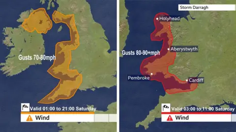
Around three million people in parts of Wales and south-west England have been sent an emergency alert from the government as Storm Darragh approaches the UK.
It is the largest use of the warning system yet and has been sent to the mobile phones of people in areas covered by the Met Office red weather warning for the storm.
The alert made a loud siren-like sound when it was delivered to devices, even if they were set on silent, and lasted for around 10 seconds.
The Met Office issued a rare red warning – the most serious type – earlier on Friday for wind.
The Met Office only issues red warnings when meteorologists believe that dangerous, potentially life-threatening weather is expected imminently.
It is in place from 03:00 to 11:00 GMT on Saturday, covering western and southern coastal regions of Wales, as well as the Bristol Channel including parts of Bristol and Cardiff.
The areas under the red warning are forecast wind gusts of 90mph (144kmph) or more, the Met Office said.
The government alert was sent to every compatible mobile phone in impacted areas, containing information about the warning and guidance on how to stay safe into Saturday.
It said Storm Darragh was expected to cause “significant disruption”, warning that strong winds can cause flying debris, falling trees and large waves, “all of which can present a danger to life”.
“Stay indoors if you can,” the alert said. “It is not safe to drive in these conditions.”
The alert said the storm may cause power cuts and disruption to mobile phone coverage, and told people to “consider gathering torches, batteries, a mobile phone power pack and other essential items you already have at home”.
Outside of test scenarios, the alert system has been used twice before, though both times on a smaller scale.
The last Met Office red warning was issued in January for winds in north-east Scotland.
Amber warnings covering Northern Ireland, Wales and the west coast of England are in place on Saturday morning.
The winds are also expected to cause large waves, power cuts affecting mobile phone services, as well as damage to buildings and homes. Transport networks are also anticipated to be affected.
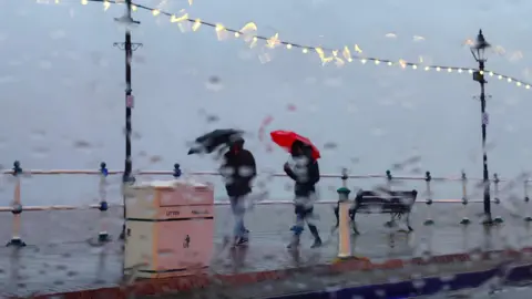
Heavy rain and strengthening winds will start to be felt across western parts of the UK on Friday evening as less serious yellow warnings come into force.
This weather pattern will turn into Storm Darragh moving into Saturday.
The Met Office said the strongest winds would subside by late Saturday morning, but that it would remain very windy until the evening, with amber warnings remaining in place until then.
A yellow rain warning, indicating a risk of flooding, is also in place in parts of the western UK.
In the north of Scotland, a yellow warning for snow is in place, with areas above 400m (1,300ft) getting up to 20cm (8in) of snow. Snow will affect higher parts of the A9 and A83, and may lead to disruption and potential closures.
The Irish Meteorological Service has also issued a red warning for wind from 22:00 on Friday across parts of counties Donegal, Leitrim and Sligo.

In Wales, all domestic football and rugby matches scheduled for Saturday have been cancelled, including Cardiff City’s Championship fixture against Watford which had been due to kick off at 15:00 GMT.
Other postponed Saturday football matches include Newport County v Carlisle United in League Two and Plymouth v Oxford United in the Championship.
Meanwhile, Welsh Rugby Union has postponed all community rugby fixtures.
As the weather worsens on Friday evening, shops and cafes in Welsh towns are making the decision to close on Saturday the run-up to the festive period.
Across the UK, there have also been widespread cancellations of winter events and Christmas markets scheduled for the weekend.
In London, all of the Royal Parks will close on Saturday which includes the popular Winter Wonderland attraction in Hyde Park.
Some travel providers warned that services were likely to be affected.
Stena Line ferries said some services across the Irish Sea on Saturday would be cancelled, while the Scottish CalMac operator said some routes could face disruption at short notice.
National Rail said some train journeys in the south west would face disruption, and urged users to check their journey before setting off.
Bristol Airport warned passengers that “disruption is expected” and passengers should check with their airline before travelling.
 BBC Weather Watchers
SP Energy Networks, a Scottish energy firm, said it was mobilising engineers to respond to power cuts “as quickly as possible” but added that customers should tell them if they lose power.
“If you experience a power outage … please don’t assume we know about it.”
The RAC has advised motorists to postpone their journeys due to the “highly unusual” red weather warning.
Spokeswoman Alice Simpson told the BBC: “Exposed rural and coastal routes will be particularly treacherous.
“Drivers in these areas should be wary of any high-sided vehicles as they are at risk of being buffeted off course or, worse still, blown over.”
Storm Darragh is the fourth named storm of the year, after Ashley, Bert and Conall.
Some parts of the UK are still recovering from Storm Bert, which caused extreme flooding and led to the deaths of five people in November.
Scientists say as the Earth’s climate warms, extreme weather events will become more frequent. For every 1C rise in average temperature, the atmosphere can hold up to around 7% more moisture.
Globally, heavy rainfall events have become more frequent and intense over most land regions, according to the UN’s climate body, which says the pattern will intensify with further warming.

