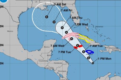
Nov. 4 (UPI) — Tropical Storm Rafael has formed in the Caribbean Sea and is most likely headed for the U.S. Gulf Coast later this week, National Hurricane Center forecasters said Monday.
The system could begin affecting Jamaica Monday night, forecasters said, adding that the system possibly will strengthen into a hurricane by Wednesday before weakening to a tropical storm again. By Saturday, the storm will be offshore of the U.S. southern coast, NHC forecasters said.
In its 4 p.m. update, the National Hurricane Center said Rafael was located about 175 miles south of Kingston, Jamaica.
It had maximum sustained winds of 45 mph and continued to move northward at about 9 mph, forecasters said.
A hurricane warning is in effect for the Cayman Islands.
Meanwhile, a hurricane watch is in effect for Cuba’s western provinces of Pinar del Rio, Artemisa, La Habana, Mayabeque, Matanzas and the Isle of Youth.
A tropical storm warning is in effect for Jamaica.
And a tropical storm watch is in effect for the Cuban provinces of Villa Clara, Cienfuegos, Sancti Spiritus, Ciego de Avila, Camaguey and Las Tunas.
Tropical storm conditions are expected to begin late Monday night in Jamaica.
According to NHC, a steady strengthening is forecast, with the depression expected to become a tropical storm sometime Monday and a hurricane by Wednesday.
Forecasters warn that “heavy rainfall” will hit the western Caribbean with heaviest rainfall occurring over Jamaica and portions of Cuba through mid-week, NHC officials said.
Some places could see rainfall totaling anywhere from 3 to 9 inches. And flooding could occur over portions of Jamaica and Cuba with “mudslides possible.”
On Monday, “minor coastal flooding” is possible in Jamaica. And the same is possible in the Cayman Islands on Tuesday.
Storm surges could raise water levels by as much as 2 to 4 feet above normal tide levels in areas of onshore winds along the southern coast of Cuba’s Pinar del Rio and the Isle of Youth.
Surf swells generated by the system are “expected to affect much of the western Caribbean during the next few days,” according to weather officials.
Heavy rain could cause local flooding and mudslides across regions. Rafael likely will transition to a Category 1 hurricane as the storm makes its way from the Caribbean to the Gulf of Mexico.
The system is expected to move near Jamaica by Monday night, on Tuesday near or over the Cayman Islands and will approach the island of Cuba on Wednesday.
The NWS station in Mobile, Ala., says there seems to be an “unusually large amount of uncertainty with the movement of this system later in the week.” And forecasters caution that it’s too early to know with fully clarity what coastal regions may see full storm effects.
Texas, however, does not appear to be in Rafael’s track to see direct landfall. The month of November has not since the 1850s brought a named system, tropical storm or hurricane to the Texas Gulf Coast.
By mid- to late week, “heavy” rainfall will spread north into Florida and adjacent areas of the Southeast United States, according to forecasters.
