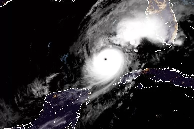
1 of 2 | Hurricane Milton regained Category 5 status early Wednesday while remaining on track to make landfall along Florida’s west coast either late Wednesday or early Thursday. Image courtesy of NOAA
Oct. 9 (UPI) — Hurricane Milton remained a Category 5 storm early Wednesday, according to forecasters who expect the storm to continue growing before making landfall along Florida’s west-central coast in about 24 hours.
In its 1 a.m. CDT Wednesday update, the National Hurricane Center said Milton was located 205 miles west-southwest of the Dry Tortugas and 360 miles southwest of Tampa, Fla.
It was carrying maximum sustained winds of 160 mph, a drop of 5 mph from 7 p.m. Tuesday, but was still a Category 5 hurricane. It was moving northeast at 12 mph.
A hurricane warning was in effect for Florida’s west coast from Bonita Beach northward to Suwannee River, including Tampa Bay. Also on Florida’s east coast from the St. Lucie/Martin county line up northward to Ponte Vedra Beach.
A hurricane watch was in effect for Dry Tortugas and Lake Okeechobee. On Florida’s west coast, from Chokoloskee to south of Bonita Beach, and Florida’s east coast north of Ponte Vedra Beach to the mouth of the St. Mary’s River. And on Florida’s east coast from the St. Lucie/Martin county line to the Palm Beach and Martin County Line.
A tropical storm warning was in effect for the “extreme northwestern” Bahamas, including Grand Bahama Island, the Abacos and Bimini. And in the Florida Keys from Dry Tortugas and Florida Bay to Lake Okeechobee. On the west coast of Florida, Flamingo to south of Bonita Beach and north of Suwanee River to Indian Pass. And on the Florida east coast, south of the St. Lucie/Martin county line to Flamingo, north of Ponte Vedra Beach all the way to Altamaha Sound in Georgia.
A tropical storm watch was in effect from north of Altamaha Sound in Georgia to the South Santee River in South Carolina.
A storm surge watch was in effect for north of Altamaha Sound in Georgia to Edisto Beach in South Carolina
A storm surge warning was in effect for the west coast of Florida from Flamingo northward to the Suwanee River, including Charlotte Harbor and Tampa Bay and Florida’s Sebastian Inlet to Altamaha Sound in Georgia, including the St. Johns River.
On Monday, Milton’s wind speeds had increased by 90 mph in less than 24 hours, reaching 180 mph. It’s being called the third-fastest rapidly intensifying storm on record in the Atlantic, according to more than 40 years of National Hurricane Center data.
Central atmospheric pressure in Milton’s eye had also fallen to 897 millibars (or 26.49 inches of mercury), according to Hurricane Hunter aircraft observations, which makes it the fifth lowest central pressure in the Atlantic basin hurricane in recorded history.
“This makes Milton one of the strongest hurricanes on record in the Atlantic Basin and the second strongest in the Gulf only behind Hurricane Rita in 2005 (895mb),” meteorologist Dylan Federico of Dallas’ KDFW-TV wrote in a Facebook post.
It then dropped to a Category 4 storm before regaining Category 5 strength.
The forecasters are warning that Milton is expected to “grow considerably in size” by the time it reaches Florida.
“Milton has the potential to be one of the most destructive hurricanes on record for west-central Florida,” the NHC said in a discussion on the storm late Tuesday.
The storm is located in the Gulf of Mexico northeast of the northern tip of the Yucatan Peninsula. Forecasters are predicting that Milton’s center will move across the eastern Gulf of Mexico Wednesday, and then make landfall along the west-central coast of Florida either late Wednesday or early Thursday.
After landfall, it will travel off the east coast of Florida into the Atlantic Ocean on Thursday, the forecasters said.
Forecasters said the storm’s intensity will fluctuate but it is expected to remain extremely dangerous when it passes over the Florida Peninsula.
The NHC said in a discussion that while it may experience some weakening, “it will likely not be enough to keep Milton from being an extremely dangerous hurricane when it reaches shore.”
Florida’s coastal residents are being warned to expect a large, destructive storm surge, devastating hurricane-force and heavy rainfall.
Forecasters predicted Tampa Bay could see a surge of between 10 and 15 feet.
Portions of the Florida Peninsula and the Keys are to receive between 6 and 12 inches of rain, with some areas to receive up to 18 inches, through Thursday, raising the risk of “catastrophic and life-threatening flash and urban flooding, along with moderate to major river flooding,” the NHC said.
Milton is bearing down on Florida’s west coast, which has already been hit by two hurricanes this season.
Hurricane Helene hit the coast near Perry in the Big Bend Region on Sept. 26 as a Category 4 storm.
Hurricane Debby struck nearby Steinhatchee as a Category 1 storm on Aug. 5.
Milton, the 13th named storm of the Atlantic hurricane season, is one of three churning in the Atlantic, but is the only one posing a threat to land. The other two are: Kirk, a Category 3 storm; and Leslie, which became a hurricane late Friday.