


Hurricane Milton maintained Category 4 status early Tuesday while remaining on track to make landfall along Florida’s west coast by Wednesday. Image courtesy of NOAA
Oct. 8 (UPI) — Hurricane Milton weakened slightly Monday night into a Category 4 storm, but was still packing sustained winds of 155 mph as it remains on course to make landfall on Florida’s west coast by Wednesday night.
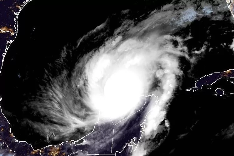
In its 1 a.m. CDT Tuesday update, the National Hurricane Center placed Milton just north of the Yucatan Peninsula and about 585 miles southwest of Tampa, Fla.
Earlier Monday, Milton’s wind speeds had increased by 90 mph in less than 24 hours to 180 mph. It’s being called the third-fastest rapidly intensifying storm on record in the Atlantic, according to more than 40 years of National Hurricane Center data.
Central atmospheric pressure in Milton’s eye had also fallen to 897 millibars (or 26.49 inches of mercury), according to Hurricane Hunter aircraft observations, which makes it the fifth lowest central pressure in the Atlantic basin hurricane recorded history.
“This makes Milton one of the strongest hurricanes on record in the Atlantic Basin and the second strongest in the Gulf only behind Hurricane Rita in 2005 (895mb),” meteorologist Dylan Federico of Dallas’ KDFW-TV wrote in a Facebook post.
The storm was moving east at roughly 9 mph, but is expected to increase in speed, forecasters said.
“The center of Milton is forecast to move just north of the Yucatan Peninsula today and approach the west coast of the Florida Peninsula on Wednesday,” the NHC said. “The hurricane will likely make landfall in Florida Wednesday night.”
Forecasters said the storm’s intensity will fluctuate but it is expected to remain an extremely dangerous, possibly deadly Category 3 or 4 storm when it passes over the Florida Peninsula. It is expected to remain a Category 1 storm as it exits eastward into the Atlantic.
Those dire warnings prompted an exodus on Monday as Tampa-area residents jammed highways while fleeing north after evacuation orders were posted.
Sheriff’s officials in Hillsborough County advised motorists of “significant backups” along northbound Interstate 75, while also warning that Interstate 275 northbound heading into Pasco County is “seeing heavy traffic” with significant slowdowns.
“We urge drivers to drive safely and expect extended delays,” the sheriff’s office said.
Mandatory evacuation orders were issued for large sections of Hillsborough, Hernando and Sarasota counties starting at 2:30 p.m. Monday, while all mobile homes and manufactured housing throughout Hillsborough County were also ordered to evacuate.
Residents in the evacuation zones “should be in a safe location no later than 7 a.m. on Wednesday, Oct. 9,” officials said. “Residents in these areas are urged to seek shelter immediately.”
A hurricane watch and tropical storm warning have been issued by the Mexican government in its Monday updates for south of Celestun to Campeche.
A hurricane warning was in effect for the coast of the Yucatan Peninsula of Mexico from Celestun to Rio Lagartos.
A hurricane watch was in effect for the coast of the Yucatan Peninsula of Mexico from Rio Lagartos to Cabo Catoche, Campeche to south of Celestun, then from the Florida Gulf Coast from Chokoloskee to the mouth of the Suwanee River, including Tampa Bay, Dry Tortugas and Lake Okeechobee.
A tropical storm warning was in effect for the coast of the Yucatan Peninsula of Mexico from Rio Lagartos to Cancun and Campeche to south of Celestun.
A tropical storm watch was in effect for the Florida Gulf Coast from Flamingo to South of Chokoloskee and the Florida Gulf coast north of the mouth of the Suwanee River to Indian Pass and Lower, Middle, and Upper Florida Keys, including Florida Bay
A storm surge watch was in effect for the Florida Gulf coast from Flamingo northward to the Suwannee River, including Charlotte Harbor and Tampa Bay.
Forecasters predicted late Monday Tampa Bay could see a surge of between 10 and 15 feet.
“On the forecast track, the center of Milton is forecast to move near or just north of the Yucatan Peninsula tonight and Tuesday, then cross the eastern Gulf of Mexico and approach the west coast of the Florida Peninsula on Wednesday,” the NHC said Monday.
While forecasters say it is too soon to specify the exact strength of the storm at landfall, or pinpoint its exact landfall location, the NHC warned of “an increasing risk of life-threatening storm surge and damaging winds for portions of the west coast of Florida,” beginning early Wednesday, with heavy rainfall to start Monday.
Portions of the Florida Peninsula and the Keys are to receive between 5 and 10 inches of rain, with some areas to receive up to 15 inches through Wednesday night, raising the risk of “considerable flash, urban and areal flooding,” the NHC said.
Meanwhile, Florida’s west coast has already been hit by two hurricanes this season.
Hurricane Helene hit the coast near Perry in the Big Bend Region on Sept. 26 as a Category 4 storm.
Hurricane Debby hit nearby Steinhatchee as a Category 1 storm on Aug. 5.
Milton, the 13th named storm of the Atlantic hurricane season, is one of three churning in the Atlantic, but is the only posing a threat to land. The other two are: Kirk, a Category 3 storm; and Leslie, which became a hurricane late Friday.