

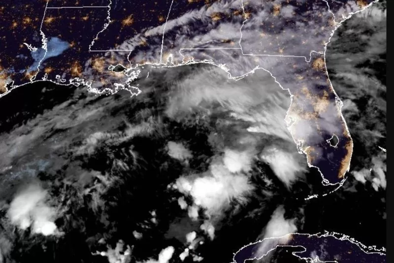


1 of 3 | Tropical Storm Milton formed in the Gulf of Mexico and is forecast to impact Florida as a hurricane. Satellite image courtesy National Oceanic and Atmospheric Administration
Oct. 5 (UPI) — Tropical Storm Milton formed in the Gulf of Mexico on Saturday afternoon with the risk of “life-threatening impacts” to Florida’s west coast, according to the National Hurricane Center, just nine days after Hurricane Helene struck the state.
Two hurricanes already were churning with no threat to land in the Atlantic Ocean: Kirk, a Category 3 storm, and Leslie, which became a hurricane late Friday.
NHC had been tracking the disturbance in the Gulf since Friday.
In the 10 a.m. update, NHC said a Tropical Depression had formed. About 2 1/2 hours later it was designated a tropical storm in an update.
Most of Florida is in NHC’s forecast cone.
Florida Gov. Ron DeSantis declared a state of emergency in 35 of the state’s 67 counties.
Milton, the 13th named storm of the season in the Atlantic, is projected to become a hurricane early Monday. The system could become a major hurricane — at least a Category 3 — while it moves across the central and eastern Gulf of Mexico, NHC said.
On the forecast track, the storm is forecast to approach Florida’s west coast by midweek.
In the 10 p.m. CDT advisory, Milton had maximum sustained winds of 45 mph and was about 365 miles west of Progreso, Mexico, and about 860 miles west-southwest of Tampa. It was moving north-northeast at 5 mph.
Tropical storm-force winds extend up to 35 miles from the center.
A Tropical Storm Watch is in effect from Calestun to Cancun, Mexico.
“Hurricane and Storm Surge watches will likely be required for portions of Florida late Sunday,” NHC said.
Interests on the Yucatan peninsula of Mexico, the Florida Peninsula, the Florida Keys and the northwestern Bahamas should monitor the progress of this system, according to NHC.
Swells “could cause life-threatening surf and rip current conditions” by early next week alongmuch of the Gulf Coast, NHC said.
Significant rain also is forecast for Florida.
Rainfall of 5 to 8 inches, with localized totals up to 12 inches, are expected across Florida, including the Keys, through Wednesday night.
“This rainfall brings the risk of flash, urban and areal flooding, along with minor to isolated moderate river flooding,” NHC said.
On Saturday, South Florida already had heavy rain and flooding from a “precursor event,” according to the National Weather Service in Miami. That includes a “marginal risk” of flash flooding for portion of South Florida.
Florida’s west coast has already been hit by two hurricanes this season.
Hurricane Helene hit the coast near Perry in the Big Bend Region on Sept. 26 as a Category 4 storm.
Hurricane Debby hit nearby Steinhatchee as a Category 1 storm on Aug. 5.
Kirk, in the 11 p.m. EDT advisory by the NHC, had maximum sustained winds of 115 mph, and was about 1,335 miles west-southwest of The Azores. Kirk was moving north-northwest at 20 mph.
There are no coastal watches or warnings in effect. Hurricane-force winds extend outward up to 60 miles from the center and tropical-storm-force winds extend outward up to 230 miles.
“Weakening is forecast through early next week, but Kirk will remain a large hurricane for the next couple of days,” NHC said.
Swells generated by Kirk are affecting the Leeward Islands, Bermuda and the Greater Antilles. They are expected to spread northward along East Coast of the United States and Atlantic Canada on Sunday, and the Azores on Monday.
They are likely to cause life-threatening surf and rip current conditions.
Leslie was designated as a hurricane in the 11 p.m. Friday NHC advisory.
In the 11 p.m. EDT update, Leslie had maximum sustained winds of 80 mph, and was about 855 miles west of the southernmost Cabo Verde Islands. Leslie was moving northwest at 9 mph.
There are no coastal watches or warnings in effect. Hurricane-force winds extend outward up to 15 miles from the center and tropical storm-force winds extend outward up to 90 miles.
NHC said a gradual weakening is forecast to begin Sunday and continue through early next week.