


Two hurricanes are churning with no threat to land in the Atlantic Ocean: Kirk, a Category 3 storm, and Leslie, which became a hurricane late Friday. Satellite image courtesy National Oceanic and Atmospheric Administration
Oct. 5 (UPI) — Two hurricanes are churning with no threat to land in the Atlantic Ocean: Kirk, a Category 3 storm, and Leslie, which became a hurricane late Friday.
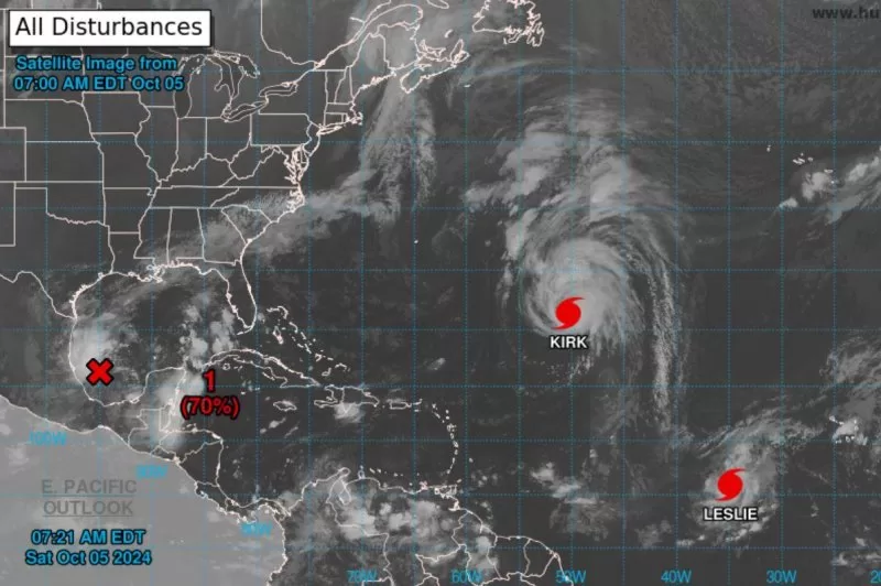
Kirk, in the 5 a.m. EDT advisory by the National Hurricane Center, had maximum sustained winds of 125 mph, and was about 990 miles northeast of The Northern Leeward Islands and about 1,575 miles west-southwest of The Azores. Kirk wa moving north-northwest at 13 mph.
There are no coastal watches or warnings in effect. Hurricane-force winds extend outward up to 60 miles from the center and tropical-storm-force winds extend outward up to 220 miles.
“Weakening is forecast through early next week, but Kirk will remain a large hurricane for the next couple of days,” NHC said.
Swells generated by Kirk are affecting the Leeward Islands, Bermuda, and the Greater Antilles. They are expected to spread to the East Coast of the United States, Atlantic Canada, and the Bahamas on Saturday night and Sunday, and to the Azores on Monday.
They are likely to cause life-threatening surf and rip current conditions.
Leslie was designated as a hurricane in the 11 p.m. Friday NHC advisory.
In the 5 a.m. EDT update, Leslie, the 12 named storm in the Atlantic this season, had maximum sustained winds of 80 mph, and was about 755 miles west-southwest of the southernmost Cabo Verde Islands. Leslie was moving west-northwest at 7 mph.
There are no coastal watches or warnings in effect. Hurricane-force winds extend outward up to 10 miles from the center and tropical-storm-force winds extend outward up to 70 miles.
NHC said additional strengthening is possible through Saturday night with a gradual weakening trend forecast to begin Sunday.
The NHC is monitoring two disturbances.
In the Gulf of Mexico, showers and thunderstorms associated with a broad area of low pressure are located over the southwestern Gulf and gradually becoming better organized.
Development is expected with a tropical depression or storm likely to form later Saturday or Sunday as it moves slowly eastward. By early next week, the system is forecast to strengthen as it moves faster eastward or northeastward. Interests on the Yucatan peninsula of Mexico, the Florida Peninsula, the Florida Keys and the northwestern Bahamas should monitor the progress of this system, according to the 8 a.m. EDT update.
Formation chance through 48 hours is 70% and 90% through seven days.
Heavy rains are forecast to hit most of Florida late this weekend through the middle of next week.
A tropical wave is forecast to move off the west coast of Africa on Monday or Tuesday with some development possible, according to NHC.
The system is expected to move near or over the Cabo Verde Islands on Wednesday and Thursday, according to the 8 a.m. EDT update.
Formation chance through 48 hours is 0% and 30% through seven days.