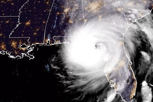
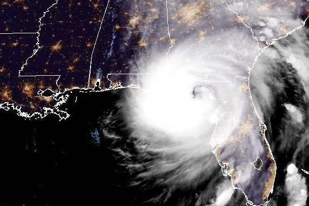
1 of 5 | The center of Category 4 hurricane Helene was forecast to make landfall late Thursday, the National Hurricane Center said. Image courtesy of NOAA
Sept. 26 (UPI) — Hurricane Helene was rapidly weakening early Friday after slamming into the Big Bend area of Florida with Category 4 winds and torrential rain, according forecasters who are warning the system could bring life-threatening damage regionwide.
The hurricane made landfall just after 11 p.m. EDT Thursday when the center of the eye reached the shore.
At 2 a.m. EDT Friday, the National Hurricane Center located the storm about 30 miles north of Valdosta, Ga., and about 85 miles northeast of Tallahassee, Fla.
It was packing winds of 90 mph, making it a category 1 storm on the Saffir-Simpson scale. It was moving north-northeast at 26 mph.
“This is an extremely dangerous and life-threatening situation,” the NHC said. “Persons should not leave their shelters and remain in place through the passage of these life-threatening conditions.”
“People are reminded to not venture out in the relative calm, as hazardous winds will increase very quickly when the eye passes,” the NHC cautioned.
Such a powerful storm will bring widespread destruction and could result in the loss of life, weather officials said.
Forecasters warned that a potentially deadly storm surge will occur along portions of the Florida Big Bend coast, where inundation could reach as high as 20 feet above ground level. They also warned of destruction from waves, too.
At least 1.3 million people in Florida, and nearly 400,000 in Georgia were without power as of 3 a.m., according to poweroutage.us.
Damaging wind gusts will penetrate well inland over portions of Georgia and the Carolinas, they said while warning residents in these regions that they could experience extended power outages.
Additionally, they said, “considerable to locally catastrophic flash and urban flooding is likely for northwestern and northern Florida and the southeast through Friday.”
Forecasters also said widespread river flooding is anticipated in a large area affected by the fast-moving storm.
“Weakening is expected after Helene moves inland, but the fast forward speed will allow strong, damaging winds, especially in gusts, to penetrate well inland across the southeastern United States, including over the higher terrain of the southern Appalachians,” the forecasters said in a Thursday evening update.
Forecasters also said hurricane-force winds extended outward as far as 60 miles from the center of the storm, while tropical-storm-force winds could be felt as far as 310 miles away. Rain totals could reach 6 inches as far north as Louisville, Ky., the NHC predicted.
A hurricane warning was in effect for Anclote River to Mexico Beach, and a hurricane watch was in effect for Entelwood to Anclote River, including Tampa Bay.
A tropical storm warning was in effect for the Florida Keys, including the Dry Tortugas; Flamingo to Anclote River, including Tampa Bay; west of Mexico Beach to the Okaloosa/Walton County Line; and Lake Okeechobee.
Storm surge warnings are in effect for Mexico Beach eastward and southward to Flamingo, Tampa Bay and Charlotte Harbor.
The storm surge warning means life-threatening danger from rising water inundation as Helene pushes water inland from the Florida coast.
“This is a life-threatening situation,” the NHC said. ” Persons located within these areas should take all necessary actions to protect life and property from rising water and the potential for other dangerous conditions. Promptly follow evacuation and other instructions from local officials.”
The NHC said the storm’s speed and intensity “will allow strong, damaging winds, especially in gusts, to penetrate well inland across the southeastern United States, including over the higher terrain of the southern Appalachians.”
The NHC said Helen is a very large hurricane. The deepest water will occur along the immediate coast near and to the east of landfall location and that surge will be accompanied by large and dangerous waves.
The NHC said surge-related flooding will depend on “the relative timing of the surge and the tidal cycle, and can vary greatly over short distances.
Florida Gov. Ron DeSantis has issued a state of emergency for 61 of Florida’s 67 counties ahead of the storm’s landfall.
“Florida is preparing for widespread impacts from Hurricane Helene,” he said.
Normally dry areas near the coast are expected to flood due to the combination of tides and the deadly storm surge, which from Carrabelle to the Suwannee River could reach as high as 20 feet.
The storm will bring heavy rainfall amounts to the Tennessee Valley on Friday and Saturday with strong, damaging winds — especially in gusts — that will penetrate well inland over the southeastern United States, including over higher terrain in the southern Appalachian mountains.
Total rain accumulations into the Appalachian’s are expected to be 6 to 12 inches, with isolated totals around 20 inches.
The NHC said the risk of several tornadoes will gradually increase through Thursday night, with greatest threat expected in parts of northern Florida into southeast Georgia, the Midlands and Low Country of South Carolina and southern North Carolina.

