I used to believe that the last thing I wanted to do on a hike was pull out my phone. That’s one of the reasons I love hiking in Angeles National Forest. I know the exact corner on Highway 2 where I lose reception.
Newsletter
You are reading The Wild newsletter
Sign up to get expert tips on the best of Southern California’s beaches, trails, parks, deserts, forests and mountains in your inbox every Thursday
You may occasionally receive promotional content from the Los Angeles Times.
But over the past year, I have edited my no-phone policy to allow a number of apps that help me turn a nice outdoor experience into a continued education of our local flora and fauna.
Every time I use one of these apps on a trail, my friends marvel over their features. And it prompts us to talk more about our environment. Rather than losing ourselves to a mindless scroll, this time on my phone helps us be more mindful about the natural world around us.
Below you’ll find the smartphone tools I most frequently use when I’m out on the trails.
Note: My list doesn’t include any navigation apps because we should be using those on the regular, or printing out a paper map. These apps are more like packing a doughnut for a hike, a little treat that can make a trip more enjoyable, but aren’t necessary for our safety and survival. I hope you enjoy using them and learn more about our native plants, animals and more!

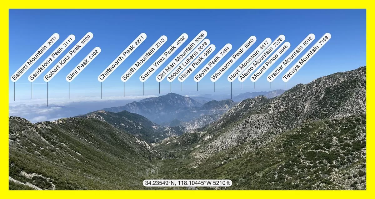
Peaks in Southern California as labeled in augmented reality app PeakFinder.
(Photo by Jaclyn Cosgrove; labeling by PeakFinder)
1. PeakFinder
For iPhone, for Android
Have you ever looked out from a summit wondering what mountain peaks you’re gazing upon? Or, while in heavy traffic on the 5, looked at the Verdugo Mountains and wondered how you could hike them?
Questions like that led me to PeakFinder, an augmented reality app that uses your phone’s camera and your location to identify the peaks around you.
To use PeakFinder, you open the app and hold your phone up like you’re taking a photo of the mountain range near you. An outline of the peaks you’re pointing at will appear and their names will pop up. When you take a photo of the range using the app, the app will automatically label each peak in your photo.
I have used PeakFinder in all sorts of settings, including from my friend’s hospital room window, while swimming in Puddingstone Lake and while on hikes through the San Gabriel Mountains.
Not only is PeakFinder a great tool to learn about our local mountain ranges, but also can be an opportunity to dabble in orienteering and triangulation if you have a paper map handy.
One thing to remember: you’ll need to download a region to ensure that once you lose reception you can still use the app. I was in Kings Canyon recently and cursed loudly when, at the top of a hike, realized I couldn’t use PeakFinder to identify anything around me because I hadn’t downloaded that region of California before leaving. Never again!
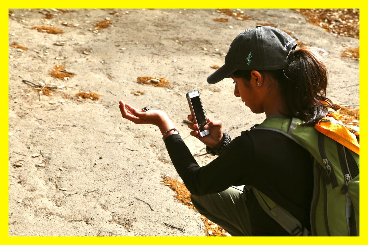
iNaturalist is used throughout the country to collect data on local organisms, including during community events known as bioblitzes, where groups work together in a short period of time to collect as much data on native species as they can. Experts advise that you only pick up wildlife under the supervision of a science or nature guide for specific reasons, such as documenting the animal for research.
(Courtesy of iNaturalist)
2. iNaturalist
For iPhone, for Android
iNaturalist is part social network, part citizen scientist collective, allowing users to upload audio and photographs of plants, animals or other organisms they observe while in nature. You do not have to know exactly what the organism is. Once you upload an image, for example, the app will suggest what you’ve viewed, and you’re asked to do your best to choose what seems most correct.
After you post your observation, other users will hopefully add to it, either agreeing with you or updating your post to suggest what they believe it is, based on evidence. As the folks at iNaturalist say, the app “is built around these civil, evidence-based discussions. We’re all trying to get to the truth.”
Since 2008, observations shared on iNaturalist have been used in more than 5,000 scientific publications. They’ve even contributed to the discovery of new species! Here in California, scientists used data from iNaturalist to track the impact that climate change is having on our beloved Joshua trees.
I’ve made almost 40 observations on the app and learned so much from using it. While hiking in Millard Canyon, I noticed a funky brownish green snake. I took a photo as it clung to a rock wall. When I got home and went to post it on iNaturalist, I realized my alleged snake had legs. Thanks to the app, I learned this peculiar dinosaur-like creature was a southern alligator lizard. (One charming fact: They choose prey close to or larger than their own body length; love that confidence.)
On another post I made, users continue to politely debate whether I documented mountain lion scat, or if it was a smaller animal, like a raccoon or fox. Yep, even uploading photos of animal poop helps contribute to science.
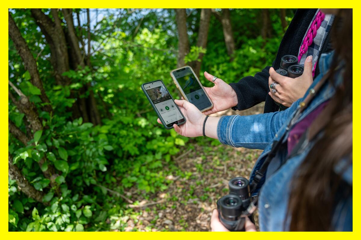
Merlin Bird ID can identify a bird through its song, chirp or other sound it makes by analyzing its spectrogram, the unique line of audio the sound makes.
(Rachel Philipson)
3. Merlin Bird ID
For iPhone, for Android
Merlin Bird ID is a birding tool developed by the Cornell Lab of Ornithology. Using its Sound ID tool, you can record birdsong near you, and it will suggest what bird is making it, based on where you are. The app can also identify birds by photo.
For much of my adult life, I’ve wanted to be a birder, but found the idea of it so daunting. There are billions of birds in the U.S. Getting started felt as arduous a task as counting every blade of grass in a yard. But since using Merlin, I have a newfound confidence. I’ve learned that the silly little birdsong that I often hear while hiking is coming from one of my favorite birds, the California quail. And when I hear a high-pitched shriek, it might be a red-tailed hawk. And, am I really hiking in California if I don’t hear a California scrub jay?
Alli Smith, the Merlin project coordinator at the Cornell Lab of Ornithology, explained to me how the app works. Merlin isn’t actually listening to the bird when you record. Rather, every bird has a unique spectrogram — the squiggly line that shows the highs and lows of the audio you’re collecting — and that functions as a reliable data point in identifying a bird. (Note: Because mockingbirds are so good at mimicking other birds, the app will sometimes suggest that you’re hearing a mockingbird and another bird, likely a sign you have a clever birdie nearby.)
The data to build these spectrograms come from the lab’s other app, eBird, which pools bird recordings and photographs from both experienced birders from around the world, and from a large collection of recordings and photographs at Cornell’s Macaulay Library.
“We’ve got about 65 million photos and almost 2.5 million sounds, most of which are submitted by eBirders and some of which are historical records,” Smith said. That includes hundreds of tapes recorded from the 1920s to present day.
To learn more about the incredible machine learning that researchers are developing to build out Merlin and other technologies, visit macaulaylibrary.org.
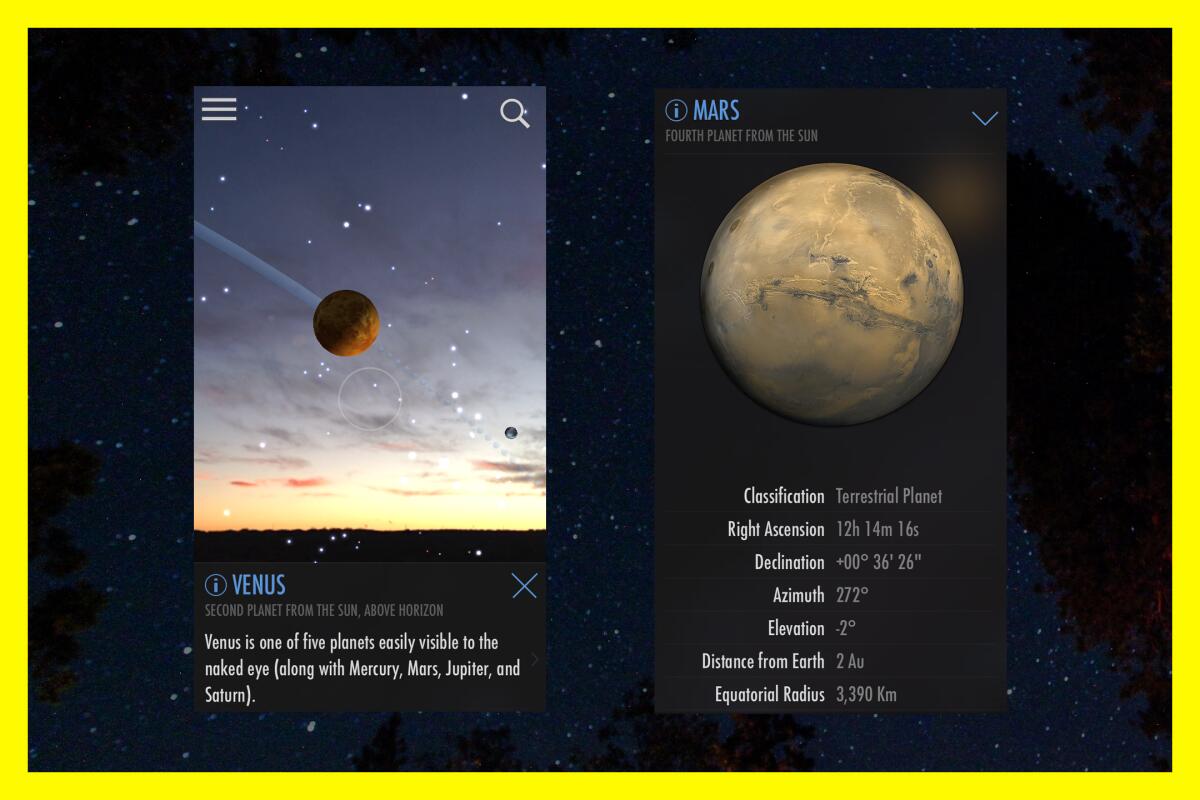
SkyView can identify a range of images in the night sky, including constellations and planets.
(Los Angeles Times photo illustration; Screenshots courtesy of SkyView)
4. SkyView
For iPhone, for Android
SkyView is another augmented reality app, similar to PeakFinder, that will overlay a map of the night sky onto your phone’s screen using your camera as its lens. There is a free and paid version available. I think the free version offers everything I need for an evening gaze into the sky.
On a recent full moon hike near Altadena, my friends and I stood on an overlook, wondering if we would see the moon, or if it would remain blocked by nearby Echo Mountain (which, given the number of headlamps we later noticed coming down, is apparently a great spot to view the full moon). We considered leaving. I pulled out my phone and used SkyView to determine that the moon was just behind the mountain. We soon noticed a brightening glow coming from behind the mountain, and in a true twist of our luck, got to watch the moon rise, a real treat. Without SkyView we might have missed the show!
If you desire something a little more comprehensive, Stellarium seems like another great option. I recently started playing around with it on my desktop. Its paid mobile version includes a catalog of 1.69 billion stars and allows you to zoom “without limits,” an exciting option for those of us with telescope envy.
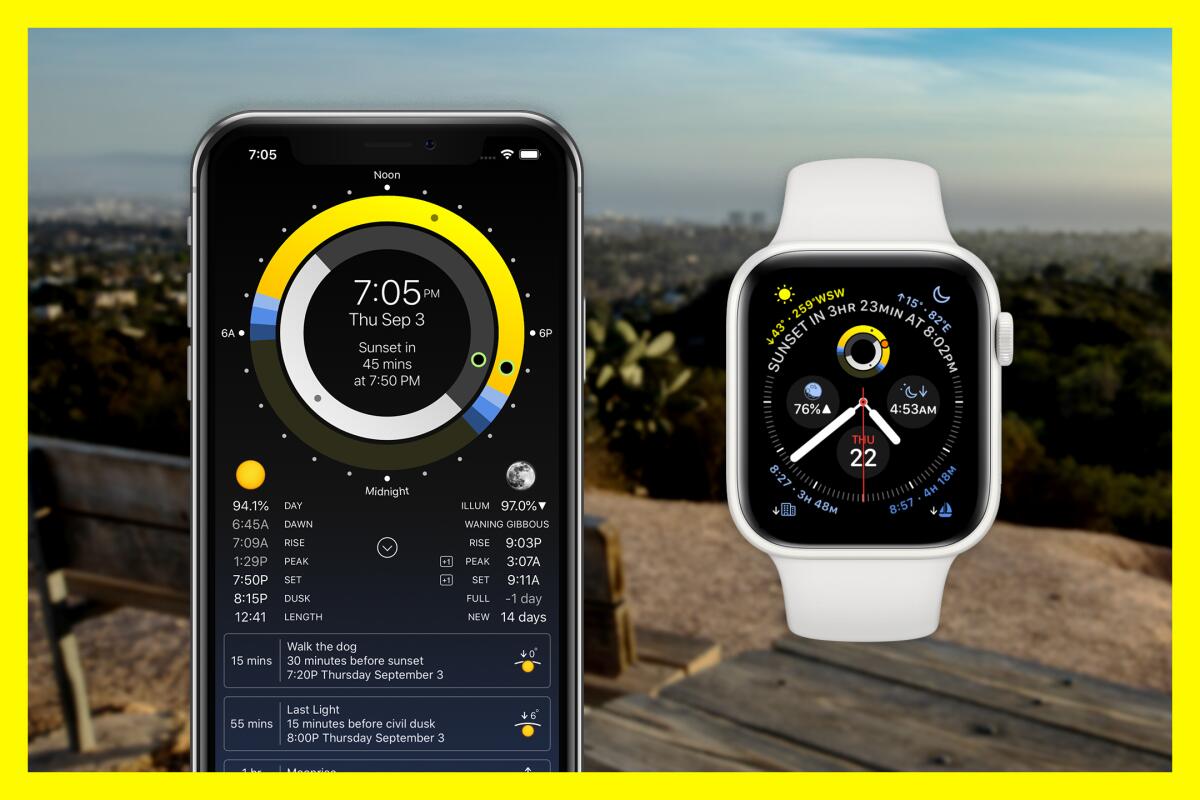
Sundial works on an iPhone, iPad or Apple Watch, displaying the time the sun and moon will rise and set, among several other data points.
(Los Angeles Times photo illustration; Screenshots courtesy of Sundial; Brian van der Brug / Los Angeles Times)
Sundial provides a tremendous amount of data on the sun and moon, charting out not only when the sun will rise and set, and the different phases of the moon, but also the different types of twilight. It offers 20 lock screen widgets and 15 home screen widgets and can also be used on an Apple Watch. You can also use Sundial’s 24-hour wheel to see when the sun and moon will rise and set any day of the year.
Especially as our days get shorter, Sundial can help you strategize your hikes. I use it to check sunrise and sunset times to determine when I should leave and how long I can stay out. I have also used it to determine what time I should schedule a full moon hike.
The app’s developer Mike Muegel has heard from several users who use the custom reminder feature, like a surfer who uses it for sunset surfing reminders or a jogger who uses it to run in perfect morning light. Or, you can use it to alert you when its the best time to walk your dog before nightfall.
Sundial is currently available only for iPhones, but Sun Surveyor is a highly rated similar app sold in the Android store. Its features include an augmented reality view and suggestions on when to get the best light for photographs.
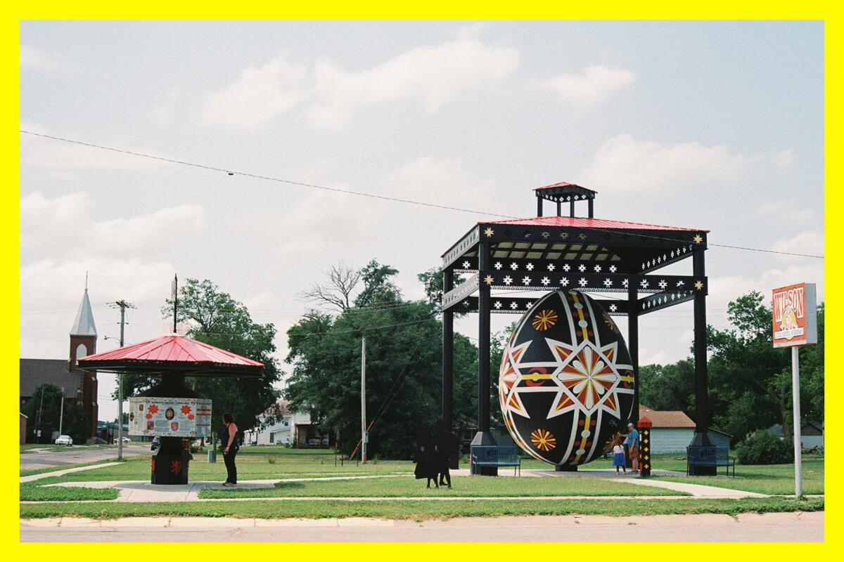
Wild writer Jaclyn Cosgrove’s family explores the proclaimed World’s Largest Hand-Painted Czech Egg in Wilson, Kan.
(Jaclyn Cosgrove / Los Angeles Times)
6. Roadside America
For iPhone, not available for Android
Roadside America is a repository of thousands of roadside attractions, searchable by city or by map. It’s a great way to discover historical sites on a road trip, especially weird and wonderful ones.
While driving to or from a hike with friends, pull out Roadside America to determine what offbeat thing you could visit during your trip. Like if you are headed to the West Fork National Scenic Bikeway off Highway 39, and you open the app, you might decide it’s a great time to also visit the Rubel Castle — a folksy medieval kingdom completed in 1986 by the late Michael Clarke Rubel —in Glendora.
Unfortunately Roadside America is currently only available on iPhones, but the desktop version of the site is free and easy to use. Before our road trip from Oklahoma to Yellowstone National Park, my sister-in-law used it to map out memorable stops, including the World’s Largest Hand-Painted Czech Egg in Wilson, Kan., and the Big Easel, a 24-by-32-foot replica of one of Vincent van Gogh’s sunflower paintings, which sits atop an 80-foot easel (also in Kansas).

3 things to do
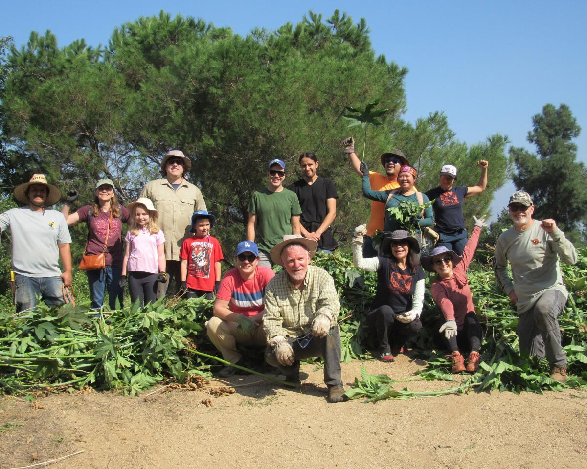
A group from Friends of Griffith Park participates in the removal of invasive castor bean near Rattlesnake Trail.
(Kathryn Louyse / Friends of Griffth Park)
1. Volunteer around L.A. for National Public Lands Day
National Public Lands Day, an annual event led by the National Environmental Education Foundation, is Saturday. Yes, this means you can visit any one of 11 California national parks that charge an entrance fee for free. Note: A reservation is required to visit Yosemite on weekends through Oct. 27. This Saturday also happens to be the nation’s largest single-day volunteer event for public lands. Consider joining volunteers at one of several events in Southern California to commemorate the day. At Griffith Park, you can go pull castor bean and other invasive plants from 8:30 to 11 a.m. so that our native plants have a better chance to thrive. Or, nearby at the Sepulveda Basin Wildlife Reserve, you can join Friends of the L.A. River and other organizations to remove trash and invasive mustard, and create and disperse seed balls to help support native plants. In Topanga, join the Sierra Club’s Santa Monica Mountains Task Force to perform trail maintenance in Topanga State Park. And, in Newbury Park, you can help the Santa Monica Mountains Fund at Rancho Sierra Vista to clear trails, work in their native plant nursery and water native trees. Find events nearest you at neefusa.org.
2. Let the dogs out at Griffith Park
Leash up Fido and join Forte Animal Rescue and naturalist Ted Mattison, also known as Ranger Ted, on a hike with fellow dog owners from 8:45 to 10:45 a.m. Sunday at Griffith Park. The group will hike the lush Fern Dell trail, which starts as a shaded jaunt on the southern end of Griffith Park. Participants will receive event-exclusive offers, a goodie bag and entry into a raffle. Space is limited. The cost per ticket is $12.51. Reserve your ticket at eventbrite.com.
3. Join a group bike ride through northeast L.A.
The Bike Oven, a community-run workshop, will host its Spoke N’ Art ride from noon to 5:30 p.m. Saturday. The group will meet at Bike Oven, 3706 N. Figueroa St, and ride to local art galleries before returning to the shop by 5:30. No bikes are available for rent. Learn more at Bike Oven’s Instagram page.

The must-read
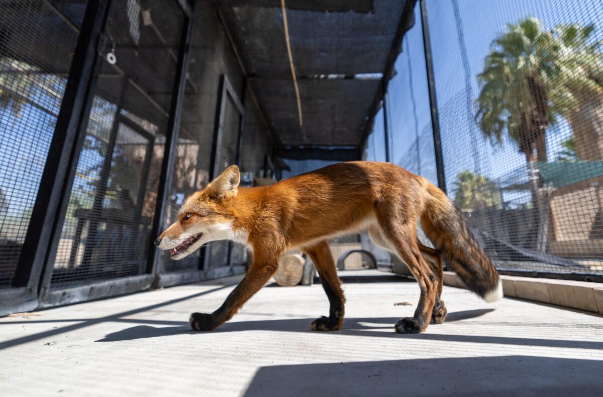
Piper, a red fox, was among about 50 animals evacuated from the Big Bear Zoo due to smoke from the Bridge Fire to the Living Desert Zoo and Gardens in Palm Desert.
(Allen J. Schaben/Los Angeles Times)
When Big Bear Alpine Zoo was recently threatened by the 39,000-acre Line fire in San Bernardino County, staffers were forced to launch a delicate rescue operation that Noah of the Ark might find impressive: a caravan of vans and trailers snaking down Highway 18 carrying eagles, owls, skunks and cranes, Times staff writer Alex Wigglesworth wrote. “I had two foxes in the back of my personal car,” said zoo curator Jessica Whiton. “It’s not ever going to smell the same.” About 50 small animals and birds were displaced, with many taken to the Living Desert Zoo and Gardens, a nonprofit zoo and botanical garden in the Coachella Valley. One temporary habitat held Niles and Daphne Crane, a pair of arthritic sandhill cranes named after the eventual couple from sitcom “Frasier.” Watch out for Daphne, though. “She likes to peck shoes,” said Whiton.
Happy adventuring,

P.S.
Outside of covering the massive Thomas fire in 2017, I haven’t spent much time in Ventura, which is a shame because the area has several great hiking trails. If you plan to head out there, make sure to first check out staff writer Jeanette Marantos’ guide on the city, which she dubs “SoCal’s last truly chill beach town.” Her list includes hiking at Harmon Canyon Preserve, where you’ll view some “astonishing ancient oaks.” I will see you there!
For more insider tips on Southern California’s beaches, trails and parks, check out past editions of The Wild. And to view this newsletter in your browser, click here.