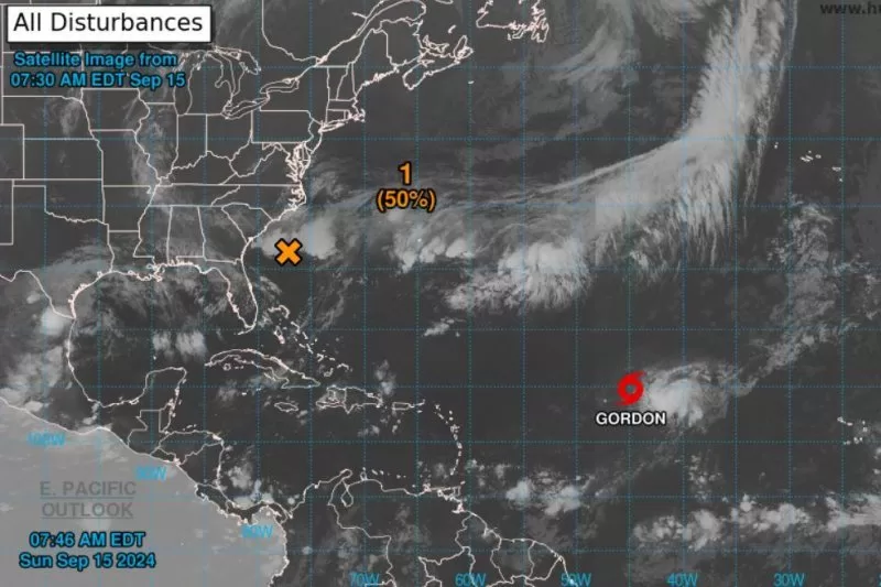
Tropical Storm Gordon was forecast to weaken into a depression later Sunday in the Atlantic. And a disturbance off the Carolinas may become a depression or disturbance later in the week. Image courtesy of National Oceanic and Atmospheric Organization.
Sept. 13 (UPI) — Tropical Storm Gordon, which became a named storm Friday, is weakening and forecast to become a depression later Sunday.
In its 5 a.m. AST update, the National Hurricane Center said Gordon had maximum sustained winds of 40 mph. Gordon was located about 1,200 miles east of the Nothern Leeward Islands. It is moving west-southwest at 10 mph and there are no coastal warnings. The storm is not a threat to land.
NHC said tropical storm-force winds were extending up to 80 miles from its center.
A westward or west-southwestward motion is forecast over the next several days with Gordon forecast to “slow down considerably through the middle of the week,” according to the NHC.
The agency expects Gordon to weaken to a tropical depression later Sunday and “it could degenerate into a remnant low at any time during the next few days.”
Gordon is the seventh named storm in the Atlantic.
Hurricanes were Beryl, Debby, Ernesto and Francine. Tropical storms were Alberto and Cindy.
Elsewhere in the Atlantic, a non-tropical area of low pressure, a few hundred miles off the Carolina coast, is producing gale-force winds north of the center. It is called AL95.
A depression or storm could “during the next day or two if the associated front dissipates and showers and thunderstorms become sufficiently organized,” NHC said.
Portions of the U.S. Southeast and Mid-Atlantic coast during the next couple of days are forecast to have gusty winds, heavy rains with the potential for flash flooding.
Formation chance through 48 hours is 50% and through seven days it is 50% in the 8 a.m. EDT update.
The next named storm would be Helene.