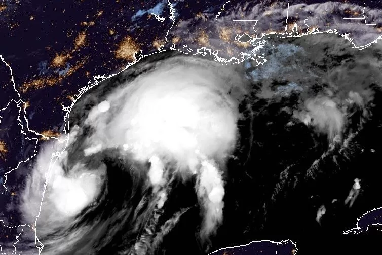
Tropical Storm Francine is expected to make landfall in Louisiana on Wednesday, potentially as a Category 2 hurricane. Image courtesy NOAA
Sept. 9 (UPI) — Francine moved little and maintained its tropical storm strength overnight, but forecasters were warning early Tuesday of a potential “life-threatening storm surge” for the Texas and Louisiana coastlines.
The storm, the sixth named system of the Atlantic hurricane season, was christened Monday after reaching tropical storm status in the Gulf of Mexico.
Forecasters are warning that it is likely to grow to hurricane strength Tuesday and will experience “significant strengthening” before making landfall in Louisiana Wednesday.
Watches and warnings have been issued in Louisiana, including a tropical storm watch for metropolitan New Orleans. Some places are under a hurricane warning.
In its 2 a.m. EDT update, NHC said Francine had maximum sustained winds of 65 mph as it was located about 125 miles south-southeast of the mouth of the Rio Grande and about 420 miles south-southwest of Cameron, La. Francine was moving north-northwest at 5 mph.
In the 11 a.m. update, the storm become a tropical storm with maximum sustained winds of 50 mph. In the 2 p.m. update, it was 60 mph.
NHC forecasters earlier said that the storm should grow to a Category 2 hurricane by Wednesday.
A hurricane warning has been issued for the Louisiana Coast from Sabine Pass eastward to Morgan City. A hurricane watch was issued for the Louisiana coast from Morgan City eastward to Grand Isle.
A tropical storm warning is in effect for Morgan City, La., to Grand Isle, La., as well as from High Island, Texas, to Sabine Pass, Texas.
A tropical storm watch has been issued from Barra del Tordo to La Pesca, Mexico, Port Mansfield to High Island, Texas, east of Grand Isle, La., to the mouth of the Pearl River, including metropolitan New Orleans, Lake Pontchartrain to Lake Maurepas.
And a storm sure watch has been called for the mouth of the Mississippi River, La., to the Mississippi-Alabama border, Lake Maurepas and Lake Pontchartrain.
Francine is packing heavy rain, which is expected to turn into urban and coastal flooding once the storm reaches land.
On the forecast track, Francine is anticipated to be just offshore of the coasts of northeastern Mexico and southern Texas through Tuesday and make landfall in Louisiana on Wednesday.
Tropical storm-force winds are extending some 140 miles from the center of the storm.
Forecasters predict rainfall from Francine could range from 4-8 inches with isolated areas receiving as much as 12 inches. Storm surge could reach as high as 10 feet in Cameron and Vermillion Bay in Louisiana.
Port Fourchon to the mouth of the Mississippi River could see storm surge as high as 7 feet while High Island, Texas, near the Bolivar Peninsula, could see it reach 5 feet.
“The deepest water will occur along the immediate coast near and to the east of the landfall location, where the surge will be accompanied by large and dangerous waves,” the center said. “Surge-related flooding depends on the relative timing of the surge and the tidal cycles and can vary greatly over short distances.”
The NHC said storm surge is not expected to pose a threat to reduction system levees.
So far this hurricane season there have been five other named storms — Alberto, Beryl, Chris, Debby and Ernesto. Beryl, Debby and Ernesto became hurricanes.
