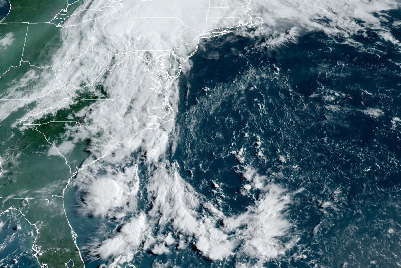
Debby was downgraded to a post-tropical cyclone Friday. Photo courtesy NOAA
Aug. 6 (UPI) — Debby was downgraded to a post-tropical cyclone on Friday, but the storm remained a threat for heavy rain and flooding from the Mid-Atlantic through Upstate New York.
The storm was located 110 miles north of Danville, Va., with maximum sustained winds of 30 mph, according to the 5 a.m. EDT advisory from the National Hurricane Center. It was moving north-northeast at 35 mph.
Flood watches and warnings were posted for portions of North Carolina, South Carolina, Maryland, and Virginia.
Flood watches included parts of eastern West Virginia, New Jersey, Pennsylvania, Delaware, Upstate New York, northern Vermont and northern New Hampshire. Tornado watches were also in effect for northern and eastern Virginia, eastern North Carolina, Maryland, eastern West Virginia and Washington.
“The post-tropical cyclone is moving toward the north-northeast near 35 mph and this motion is expected to continue, with a gradual turn more to the northeast,” the center said.
Fifteen hours after making its second landfall in the United States near Bulls Bay, S.C., early on Thursday morning, Debby was officially downgraded but was still packing plenty of rainfall.
An additional 3 to 6 inches of rainfall with locally higher amounts was forecast along with “considerable flooding” across parts of eastern South Carolina and southeast North Carolina through Friday.
The worst-hit parts of South Carolina were in line for a catastrophic maximum storm total of 20 to 25 inches following an additional 1 to 3 inches on Thursday, while parts of southeast North Carolina were expected to see another 3 to 6 inches, pushing totals there to as high as 15 inches.
“Locally catastrophic flash and urban flooding” were also forecast for a broad swath of the Atlantic seaboard stretching northward from central North Carolina across portions of Virginia. Those areas could expect 3 to 7 inches with local amounts to 10 inches, forecasters said.
In Charlotte, officials and residents prepared for flash flooding as Duke Energy reported more than 24,000 customers in Mecklenburg County were without power as of Thursday morning.
Dozens of downed trees were reported across the city of Charlotte as a flash flood warning remained in place until 7 p.m.
The storm first made landfall in Florida’s Big Bend area Monday as a Category 1 hurricane, before weakening as it moved across the eastern coasts of Georgia and South Carolina. It made its second landfall around 2 a.m. Thursday about 20 miles northeast of Charleston, S.C., and 65 miles southwest of Myrtle Beach, S.C.
Debby may produce “a few tornadoes” starting Thursday night in an area stretching from central and eastern North Carolina into central and southeast Virginia, with the threat shifting northward into parts of New Jersey and eastern Pennsylvania on Friday, the NHC said.
Meanwhile, potentially life-threatening surf will continue to affect the southeastern U.S. coast for “another day or so,” officials said.

