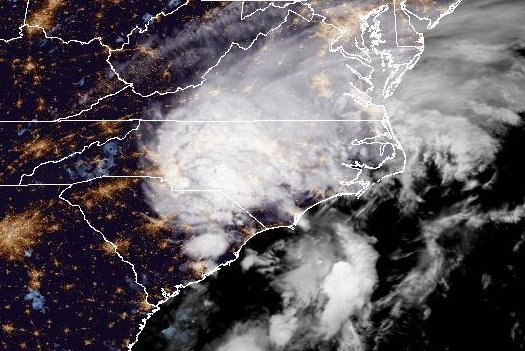
Tropical Storm Debby made landfall early Thursday near Bulls Bay, S.C. Image courtesy of NOAA
Aug. 6 (UPI) — Tropical Storm Debby has made its second landfall in the United States, moving inland early Thursday near Bulls Bay, S.C.
The storm first made landfall in Florida’s Big Bend area Monday as a Category 1 hurricane, before weakening as it moved across the eastern coasts of Georgia and South Carolina.
The National Hurricane Center announced its second landfall in its 2 a.m. Thursday update as it located the storm about 20 miles northeast of Charleston, S.C., and 65 miles southwest of Myrtle Beach, S.C.
It was moving northwest at 5 mph, it said.
“Additional weakening is forecast today as the center moves father inland,” it said.
The forecasters are warning that a “major flood threat” continues for portions of the Carolinas and western Virginia due to the storm.
Up to an additional 9 inches of rainfall is forecast for eastern South Carolina that has already been battered by Debby, equalling a combined 25 inches of rain. Meanwhile, North Carolina is expecting a cumulative 15 inches.
“Heavy rainfall across portions of the Carolinas is expected to persist through Thursday along with areas of considerable flooding,” the NHC said.
“Expected heavy rainfall will also result in considerable flooding impacts across portions of the mid-Atlantic state and Northeast through Saturday morning.”
The combination of storm surge and tide will cause normally dry areas near the coast to flood with rising waters moving inland from the shoreline, the NOAA reported.
The water could cause between 1 foot and 3 feet of flooding from the South Santee River to Ocracoke Inlet, including the Neuse and Pamlico rivers, in South Carolina.
A tropical storm warning is in effect for Edisto Beach, S.C., to Surf City, N.C. while a tropical storm watch has been issued for norther of Surf City to Beaufort Inlet, N.C.

