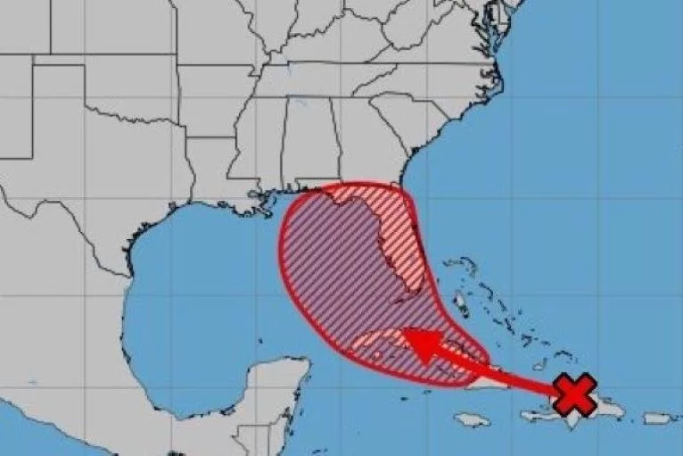
The projected path of what is now known as Tropical Disturbance Invest 97L is shown in a National Hurricane Center forecast from Thursday afternoon. Florida Gov. Ron DeSantis issued an emergency preparedness declaration after forecasters predicted it could soon form into a slow-moving tropical depression brining heavy rain to the state. Graphic courtesy National Hurricane Center
Aug. 1 (UPI) — Florida Gov. Ron DeSantis issued an emergency preparedness declaration Thursday as a tropical disturbance dubbed Invest 97L headed toward the state’s Gulf Coast and showed signs of strengthening.
The declaration instructing state officials to prepare for possible serious damage from severe weather was issued at 5 p.m. after the National Hurricane Center determined that conditions were “highly conducive” for the disturbance to develop into a more serious tropical depression targeting the eastern Gulf of Mexico near the Florida Peninsula during the weekend and into early next week.
The governor’s office cited reports predicting a “significant threat of heavy rainfall over most of the State of Florida, with the possibility of at least 12 inches of rainfall over the next seven days,” which could result in flash flooding, river flooding, coastal flooding, erosion and gusty winds.
“Florida is monitoring Invest 97L in the Atlantic, which is expected to strengthen and potentially make landfall as early as this weekend,” DeSantis said in a social media post. “It will be slow-moving and bring lots of rain that could cause significant flooding.”
The National Hurricane Center reported at 2 p.m. the tropical wave was producing a large area of disorganized showers and thunderstorms over Hispaniola, Puerto Rico, the Southeastern Bahamas, and the adjacent waters of the southwestern Atlantic and northeastern Caribbean Sea.
“Development of this system should be slow to occur during the next day or so while it moves west-northwestward over portions of the Greater Antilles,” forecasters said. “However, environmental conditions are forecast to be more conducive for development after the wave passes the Greater Antilles, and a tropical depression is likely to form this weekend or early next week over the eastern Gulf of Mexico near the Florida Peninsula.”
The wave’s potential to form into a tropical depression was rated as “high” at 70% during the next through seven days.

