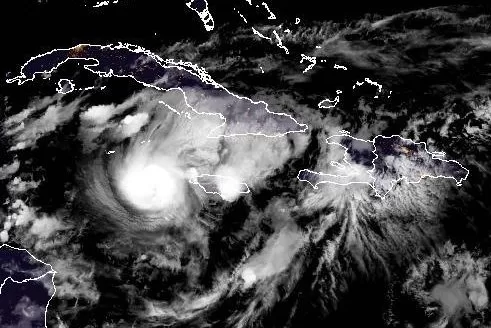
Hurricane Beryl is shown pulling away form the Caribbean Island nation of Jamaica on Wednesday Night. Image courtesy NOAA
July 4 (UPI) — Hurricane Beryl was pulling away from Jamaica on Wednesday night as it remained on course for Mexico’s Yucatan Peninsula, forecasters said.
As of 11 p.m. EDT, Beryl’s eye was located in the Caribbean Sea 165 miles southeast of Grand Cayman Island and 560 miles east-southeast of Tulum, Mexico, the National Hurricane Center said.
It was packing maximum sustained winds of 130 mph, making it a Category 4 storm, while moving west-northwest at 21 mph.
The forecasters are saying Beryl is expected to pass just south of the Grand Cayman Island overnight “at or near major hurricane intensity.”
Though expected to weaken afterward, Beryl is forecast to remain a hurricane until it makes landfall on the Yucatan Peninsula.
Hurricane warnings were in effect for Jamaica, Grand Cayman, Little Cayman and Cayman Brac, as well as the Yucatan Coast from Puerto Costa Maya to Cancun.
Hurricane watches were also in effect for the Yucatan Coast south of Puerto Costa Maya to Chetumal, as well as north of Cancun to Cabo Catoche.
Forecasters warned Jamaica and the Cayman Islands to expect “life-threatening winds and storm surge” on Wednesday. They were expecting Beryl to produce rainfall amounts of 4 to 8 inches, with isolated totals of 12 inches, across Jamaica and the southwestern Haitian Peninsula through late Wednesday.
Beryl made landfall on Grenada’s Carriacou Island in the Caribbean Sea with maximum sustained winds of 150 mph around 11 a.m. Tuesday. It is the strongest known hurricane to pass through the Grenadines, according to data from NOAA since 1851.
On Sunday, Beryl became the earliest Category 4 hurricane on record in the Atlantic and the only Category 4 storm ever recorded in June.
It then later became the earliest Category 5 storm in history before being downgraded to a Category 4 storm on Tuesday.
Only seven named storms have formed over the last 173 years in this sector of the Atlantic before July 4, according to Accuweather.
Meanwhile, Alberto, the first tropical storm of the season, made landfall over Mexico on June 20 and then pummeled Texas the next day with rain while Tropical Storm Chris, the third named storm of the season, made landfall in eastern Mexico late Sunday.