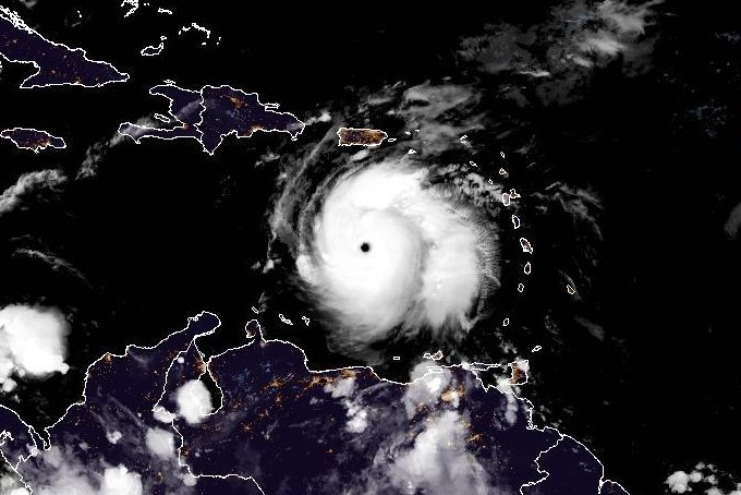
Hurricane Beryl, a Category 5 storm, churns through the Atlantic Ocean. Photo courtesy NOAA
July 2 (UPI) — Hurricane Beryl, already a Category 5 storm, continued to intensify as it headed toward Jamaica early Tuesday, forecasters said, a day after it battered the southern Windward Islands with tropical storm conditions and made landfall in Grenada as a powerful Category 4 system.
The storm was anointed the first Category 5 of the Atlantic hurricane season and the earliest to hit that mark in history on Monday as it reached maximum sustained winds of 160 mph.
But the National Hurricane Center said Tuesday that it was still gathering speed.
In its 2 a.m. EDT update, the center said Beryl was packing sustained winds of 165 mph as it was moving west-northwest at 22 mph.
Beryl was located about 445 miles east-southeast of Isla Beata, Dominican Republic, and about 775 miles east-southeast of Kingston, Jamaica.
The government of Jamaica has issued a hurricane warning for the island.
A tropical storm warning is in effect for the south coast of Dominican Republic from Punta Palenque westward to the border with Haiti, and the south coast of Haiti from the border with the DominicanRepublic to Anse d’Hainault
The southern Windward Islands include Grenada, St. Vincent and the Grenadine Islands and Martinique.
On the forecast track, the center of Beryl will move quickly across the across open waters in the southeastern and central Caribbean Sea on Tuesday and is forecast to pass near Jamaica on Wednesday.
“Fluctuations in strength are likely during the next day or so, but Beryl is expected to still be near major hurricane intensity as its moves into the central Caribbean and passes near Jamaica on Wednesday,” the NHC said.
“Additional weakening is expected thereafter, though Beryl is forecast to remain a hurricane in the northwestern Caribbean.”
The center said that hurricane-force winds extended outward up to 40 miles from the center of the eye with tropical-storm-force winds extending up to 125 miles.
Beryl had slightly weakened to a Category 3 storm early Monday with winds of 120 mph, before strengthening again to a Category 4 then a Category 5.
The storm is forecast to reach Mexico as a tropical storm on Friday.
The United States is not expected to be affected by the storm.
Beryl made landfall on Grenada’s Carriacou Island in the Caribbean Sea with maximum sustained winds of 150 mph around 11 a.m. It is the strongest known hurricane to pass through the Grenadines, according to data from NOAA since 1851.
There were “widespread reports of destruction and devastation in Carriacou and Petite Martinique,” Grenada Prime Minister Dickon Mitchell said in a Monday news briefing. “In half an hour, Carriacou was flattened.”
No immediate reports of deaths or injuries were reported.
“You have to appreciate the ferocity and the strength of the hurricane and therefore we are not yet out of the woods,” he said. “And we are not able to say for sure that no one has been injured or there has been no loss of life as a result of the hurricane.”
About 95 percent of the island of Grenada has lost power due to Hurricane Beryl, Neila K. Ettienne, press secretary for the office of the prime minister, told CNN on Monday. Telecommunications across Grenada are down, and some individuals have lost internet service, Ettienne explained.
The government had difficulty posting updates on Facebook.
On Sunday, Beryl became the earliest Category 4 hurricane on record in the Atlantic and the only Category 4 storm ever recorded in June.
It is now the earliest Category 5 storm in history.
Only seven named storms have formed over the last 173 years in this sector of the Atlantic before July 4, according to Accuweather.
Alberto, the first tropical storm of the season, made landfall over Mexico on June 20 and then pummeled Texas the next day with rain.
Tropical Storm Chis, the third named storm of the season, made landfall in eastern Mexico late Sunday.
