Accuweather tracker
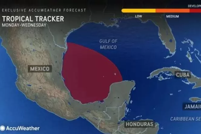
June 15 (UPI) — The 2024 Atlantic hurricane season is just two weeks old, but AccuWeather hurricane experts have already been tracking a few weather systems of interest across the basin. One expected to move into the Gulf of Mexico early next week has a decent chance of becoming the first tropical depression or named storm of the season.
On Thursday afternoon, AccuWeather upgraded the outlook for this system to a “high” risk for development, which can occur between Monday and Wednesday. This comes just a day after becoming the first source to issue a “medium” risk for development. In that timeframe and after, impacts from the storm are expected in both Mexico and the United States.
The prospects of development from this system, as well as the recent deluge of rain in Florida from a tropical rainstorm, are both early harbingers of what is expected to be a very busy Atlantic hurricane season.
All eyes on the Bay of Campeche into next week
Alberto is the first name on the 2024 Atlantic list, and there’s a good chance that AccuWeather’s hurricane experts could be tracking a storm with that name by next week. With the tropical rainstorm moving off the Atlantic coast and not claiming it first this weekend, that name would then fall to a potential storm in the Bay of Campeche, which forms the far southern part of the Gulf of Mexico.
“The ingredients are in place for tropical development across the southern Gulf of Mexico,” said AccuWeather Senior Meteorologist Adam Douty. “These ingredients include light winds and very warm water.”
In the days prior, widespread shower and thunderstorm activity will continue to inundate the countries of Central America and southern Mexico with heavy rain that can lead to flooding and life-threatening mudslides.
There will be a narrow window of both time and space for a tropical system to form. “The main limiting factor for development will be the close proximity to land and limited time over water,” added Douty. “Despite these limitations, it looks increasingly likely that a tropical depression or storm can develop.”
Because of its notoriously warm waters, the Bay of Campeche is considered a classic breeding ground for tropical systems. It also is a dangerous place for development to occur, because there is virtually no way out for a tropical system except by land.
“Regardless of how strong this potential tropical system can get, heavy rain is expected to be the most significant impact,” said Douty.
Tropical moisture preceding any tropical development will reach across eastern Mexico and even north into Texas and Louisiana as early as Sunday. Through the middle of next week, as the center of any storm that develops moves west toward mainland Mexico, several inches of rain and flooding can occur in this zone. Along the coast, there can also be dangerous surf and rip currents for several days.
“Should the system strengthen into a tropical storm, a smaller area of locally damaging winds would be possible where the center of the storm moves onshore,” Douty pointed out.
Elsewhere, watching the Eastern Pacific
The Gulf of Mexico isn’t the only place that AccuWeather’s hurricane experts are watching during this early part of the season.
A tropical rainstorm that brought feet of rain and flooding to Florida was centered off the Southeast coast midday Friday. AccuWeather meteorologists were confident on Friday afternoon that this feature had lost its opportunity to develop into a tropical system.
Meanwhile, the Eastern Pacific, now nearly a month into its hurricane season, is still awaiting the first named tropical system. While AccuWeather is monitoring an area of disturbed weather loosely associated with the same area of showers and thunderstorms that can lead to the Gulf of Mexico system, odds for further development are low.
“AccuWeather hurricane experts are monitoring an area near the southern coast of Mexico for a low chance of tropical development between June 15 and 17,” said AccuWeather Senior Meteorologist Dan Pydynowski. “Regardless of development, a surge of tropical moisture will lead to heavy rainfall across portions of Central America and southern Mexico this weekend into early next week.”
The Atlantic hurricane season runs from June 1 to Nov. 30, and the historical average date of the first named system in the basin is June 20. The Eastern Pacific hurricane season runs from May 15 to Nov. 30, and the historical average date of the first named storm in the basin is June 10.

