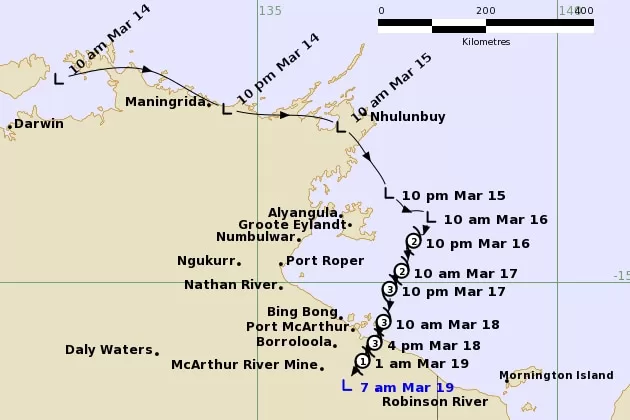
Ex-Tropical Cyclone Megan has been downgraded to a tropical low after rapidly weakening following its coastal crossing as a category three system on Monday afternoon.
But the low has been forecast to continue moving slowly across the NT this week, bringing heavy rain and potential flooding to parts of Central Australia.
Ex-Tropical Cyclone Megan crossed the NT coast in the south-western Gulf of Carpentaria at about 3:30pm on Monday, producing wind gusts as high as 170 kilometres per hour at its strongest point.
It was downgraded to a category two system late on Monday night, then category one early on Tuesday.
At 7:30am Tuesday the Bureau of Meteorology (BOM) declared the system had weakened below cyclone strength and predicted it would continue to track west through inland parts of the NT over the next few days.
The system is still producing strong winds and heavy rainfall in parts of the territory, the BOM has warned.
Earlier on Tuesday, before the system was downgraded, BOM senior forecaster Angus Hines said ex-Tropical Cyclone Megan had already brought heavy rainfall of up to 500 millimetres to communities in its path.
He said when the system became a low, winds would start to ease, but it would continue to bring heavy rain to central parts of the NT throughout this week.
“We’re mostly worried about further, persistent heavy rainfall leading to potential flooding, and that does cover a pretty broad part of the northern Gregory and parts of the Carpentaria,” he said.
“[The cyclone has] so far avoided those larger population centres but there are still some remote communities that are likely to be majorly affected over the next few days, particularly by heavy rainfall and potentially isolation.”
“The centre of the Northern Territory is going to be inundated with persistent, heavy rain for the next few days.”
