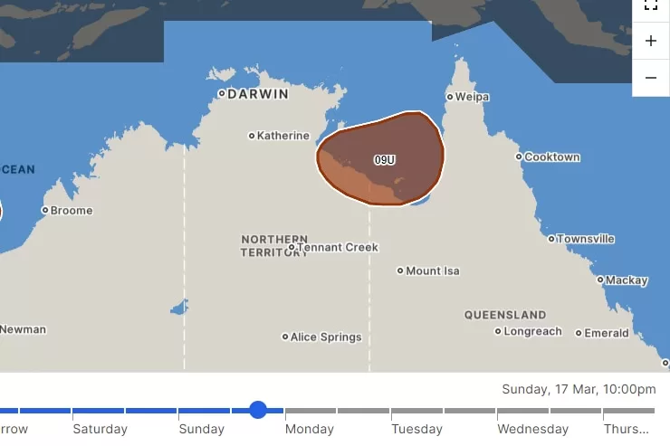
- In short: Tropical low 09U is expected to reach peak intensity on Sunday morning with a 55 per cent chance of forming into a cyclone
- If it does reach cyclone status, it will be the fourth to affect northern Queensland since December.
- What’s next? The system is expected to weaken on Monday and move west across the Northern Territory.
Flood-weary residents who have been isolated in Queensland’s north since the start of the year are bracing for the chance of a fourth cyclone since December.
There is a 55 per cent possibility that a tropical low will form into a cyclone in the Gulf of Carpentaria on Sunday, threatening to dump rain on flooded river catchments.
The low has been sitting near the Tiwi Islands north of Darwin and, according to the Bureau of Meteorology (BOM), will track east across the Top End and into the gulf on Friday.
It is set to intensify in gulf waters with a moderate 40 per cent chance of forming into a cyclone on Saturday night, when it starts to make landfall in the gulf’s south-east region.
The system has a high chance of reaching cyclone status on Sunday as it slowly moves south.
Meteorologist Patch Clapp said the warm gulf waters were the perfect climate for the tropical low system to develop into a cyclone, although there was a “lot of uncertainty with weather systems like this”.
“There is always the possibility of it becoming a cyclone, particularly at this time of year in those gulf waters,” he said.
“With the monsoon active through the northern parts of the country, that can support systems, so it will be a question of timing and other influences at play.”
The system is expected to weaken on Monday as it makes a U-turn and heads back across the Northern Territory.
If it forms into a cyclone, it will be the fourth to cause potential problems for the region, which felt the repercussions of Tropical Cyclone Jasper after it made landfall near Cairns in December.
Then came Cyclone Kirrily, which sparked evacuations in Burketown, before Cyclone Lincoln caused fatal flooding in the region during mid-February.
A ‘relentless’ wet season
Residents of communities surrounded by floodwaters for three months are eager to see river levels start to recede and roads open up.
Instead, they are preparing for even more water to enter swollen river systems, according to North West District Disaster Management Group (DDMG) emergency management coordinator Elliott Dunn.
“Poor old Doomadgee has been isolated since early January. The last thing they need is any more rain in the Nicholson catchment,” Mr Dunn said.
“This has just been a very protracted, relentless wet season.
“People are prepared but you do get very tired when you’re getting one hit after the other like we’re seeing this season.”
Mr Dunn urged outback residents to stay put as the system passed through the region.
“Please don’t use the roads and don’t take any stupid risks as flood conditions increase across the area this weekend,” he said.
