Hassan Gagiyo Dumbari thought with the huge investment he made last year in his farm in Gashua, Northeast Nigeria, his economic problems would be over.
The flood that ravaged his farm last year dashed his hopes.
“My problems became new. Because we were having bumper harvests in our farms before the flood despite the economic hardship, we are getting sustenance from there. But it has reached an extent where there is no grass (kara) to feed livestock, not to even talk of the food we will store until the next season,” he said.
Gashua, the headquarters of Bade local government area of Yobe State in the northeastern part of Nigeria, is a few miles away from River Jama’are in Bauchi and River Hadejia in Jigawa State and has a population of more than 125,000 people.
The affected area is within the Hadejia-Nguru wetlands in western Yobe state, Gashua, on the floodplain of the Komadugu Yobe river and its branches. With an average height of less than 300 meters above sea level, its terrain is primarily lowland, which makes it susceptible to flooding.
He said he learnt the flood was coming by word of mouth, from people in further away communities. It sounded like a folk tale, he said. But when the water arrived, it was all too real. He had never experienced flooding like it in his life.
“We have experienced flooding in the past between 2000 and 2003, and it didn’t wreak havoc like this. Then I think we saw something like that in 2011. But the recent one is unprecedented,” he said when HumAngle reached him by phone.
“The flood has affected more than 80 houses in Gashua. I have been affected by the flood in many parts. Aside from my submerged farm, there is nothing left in my brother’s house but rubbles. You see, I have been affected on every part.”
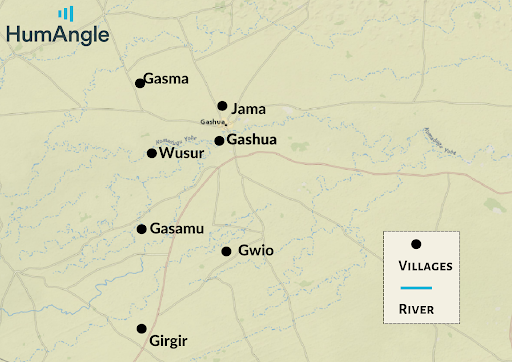
The flood waters spread over a huge area. It is a low lying place where many river tributaries join together and flow eastwards into the Yobe river. It is usually marshy, but the heavy rains last year meant the water broke over the marshes, affecting dozens of villages between Gasma and Girgir, as much as 20kms apart.

It ravaged many communities, but the loss of life was minimal.
“A Fulani man, his wife and five children in Tabawa few miles away from Gashua, were trying to flee in a truck when it fell into a ditch. Only the man survived,” Hassan Dumbari said.
When asked about any measure they have taken to control future recurrence, he said there is nothing they can do.
“It resulted in food scarcity because food is now expensive,” Hassan complained bitterly.
Rabiu Abubakar, a trader in Gashua, also said, “now there’s food scarcity which came up as a result of the flood.
“If there’s food everywhere, even if it will cost a lot, it will not be unaffordable.”
Before a bag of an average grain ranges from 7,000 to 8,000. But now, because of the flood, the price ranges from 18,000 to 20,000.
“Now you will see villagers foraging for food just like residents of urban areas,” the trader added.
It affected them as traders, he said. “A farmer doesn’t cultivate spaghetti, oil and other items. So they must come to the market to get this, but the flood has made them live in a state of penury.”
“When the flood happened, if someone owes you money, they will directly tell you they have invested all they had in the farms, and now the flood has washed away everything.”
He said that has seriously affected his trade.
On the part of the government, the residents of the town said there has not been any form of humanitarian intervention to alleviate the situation they found themselves in.
Warnings have been issued that there will be more flooding this year.
The Nigerian Hydrological Services Agency (NIHSA) says about 178 local government areas in 32 states and the FCT are likely to experience flooding.
But despite this, victims of Gashua last year’s flood said they don’t have any contingency plans for if it happens again, they believe there is nothing they can do.
“To the best of my knowledge, there is no any contingency plan. This is nature, it is test from God. One can’t help it,” Hassan said.
Listing Yobe State as one the Highly Probable Risks Areas (HPA), the agency said it would be high in terms of effect on the populace, agriculture, livelihood, livestock, infrastructure, and the environment.
Experts agree that flooding in the area is caused by river bank overflows and torrential rainfall while others blame poor urban planning that make residents not properly utilise their drainages.
Support Our Journalism
There are millions of ordinary people affected by conflict in Africa whose stories are missing in the mainstream media. HumAngle is determined to tell those challenging and under-reported stories, hoping that the people impacted by these conflicts will find the safety and security they deserve.
To ensure that we continue to provide public service coverage, we have a small favour to ask you. We want you to be part of our journalistic endeavour by contributing a token to us.
Your donation will further promote a robust, free, and independent media.

